The Churches of Britain and Ireland
| Stronsay, Orkney Islands
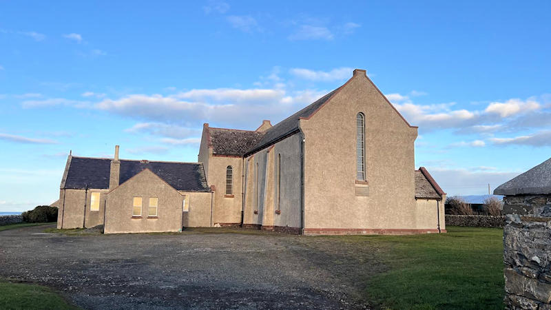
A Church of Scotland Mission Hall used to stand a little way east of Whitehall village at HY 6620 2829. It pre-dated a map of 1902, and this source (scroll down) says that it was badly damaged or destroyed in a storm in 1936, and a new chapel was rapidly put in place "on the same site but further away from the public road". It survives, and after several changes of use, plans are afoot to redevelop it as a Heritage Centre. Streetview saw it in 2022. The site of its predecessor is indicated by the grassed area plus driveway). Moncur Memorial Church. HY 6542 2514. © Richard Beghin (2025). This source, which dates it to 1955, possibly incorrectly says that it's now the only church on the island - see Our Lady, below. Link. Category C listed. Older O.S. maps show a United Presbyterian Church (later United Free) on the same site. A newspaper article dates it to 1858, and includes photos of it during its demolition. More history from the same series of newspaper articles can be read here (with photos of the U.P. church) and here. Our Lady (R.C.) at Whitehall, as seen by Streetview in 2010. A 2015 photo on Geograph shows it when it still had its signage. Although still apparently active (at least, according to this website), I haven't been able to find any further on-line information about it. It presumably was still active when this 2023 video was taken, showing the exterior and interior. HY 6594 2847. St. John (CoS) stood overlooking Mill Bay at HY 6550 2594. Pre-dating a map of 1882, it was closed (according to a reference already given in the Moncur entry above) in 1931. Some photos can be seen here (scroll down) where it says it now forms part of some farm buildings. Its roof is perhaps visible in a Streetview from 2010, to the left of the telegraph poles. St. Ninian (Episcopal) stood in Whitehall village "between (the) houses of Cedarbank and Glenfield" (source). This puts it at about HY 6599 2829. This church also fell victim to a storm, in 1952. It stood immediately to the left of the house seen in a Streetview from 2010.
|
||
03 October 2025
© Steve Bulman