The Churches of Britain and Ireland
|
St. Leonards-on-Sea, East Sussex
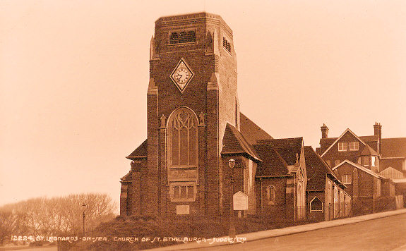
St. Leonards-on-Sea on Wikipedia. Christ Church on London Road and Silchester Road. TQ 8024 0915. From an old postcard (franked 1906), in Steve Bulman's Collection. A Streetview from 2018 provides a modern view. Link. Grade II* listed, wherein it's dated to 1873-5, with later tower. Old large-scale O.S. maps label the adjacent building to the south of Christ Church as Old Christ Church (2024 Streetview). Its grade II listing, which calls it Renaissance House, explains that it was a mid-19th century church, which was enlarged by the addition of an upper floor in 1896 to serve as a school. TQ 8026 0912. A Congregational Mission Church stood on Bexhill Road, West Marina, at TQ 7813 0886. Pre-dating a map surveyed in 1898, it was still showing as a place of worship on mid-20th century maps. A 1910 photo of it can be seen here. It's now home to a theatrical group - 2024 Streetview. An otherwise unidentified Chap. shows on Kenilworth Road on a map of 1899, at TQ 8012 0902. It had gone out of use by the middle of the last century, but it survives, and was seen by Streetview in 2024. A photo of it on Wikipedia identifies it as a Gospel Mission Hall "registered in 1920". Whether it was the same church but un-registered before this, or had belonged to another church, is unclear. Greek Orthodox Church of St. Mary Magdalene on St. Margaret's Road and Church Road, as seen by Streetview in 2024. It was built as the Anglican St. Mary Magdalene in 1852, tower added later. The present congregation moving in in 1983, according to its grade II listing. TQ 8064 0910. Link. The Methodist Church (2024 Streetview) is on Bohemia Road and Upper Park Road. Older maps label it as Wesleyan, and it pre-dates one surveyed in 1897. TQ 8016 1027. Link. The former Norman Road Wesleyan Methodist Chapel, as seen by Streetview in 2024. The caption here dates it to 1901, closed 2008, and replacing a predecessor on the same site of 1836, which had burned down. TQ 8022 0897. St. Ethelburga, on St. Saviour's Road, built in 1929. TQ 7844 0894. From an old postcard in Kevin Gordon's Collection. Link. History page. Older O.S. maps show that it stands on the site of St. Saviour's Mission Church, built no later than 1898. St. John the Evangelist on Pevensey Road and Upper Maze Hill, as seen by Streetview in 2024. Its grade II listing dates it to 1950-4, retaining parts of its predecessor of the same name, a Blomfield church, of 1881, which had been bomb damaged in WWII. A good history here where it says that there have been four churches on the site, the earliest an iron church of 1865 which only survived a year. TQ 7978 0937. Link. St. Leonard (2024 Streetview) on Undercliff is, according to Google Streetview in 2025, permanently closed. TQ 7969 0886. Link says it stands on the site of an earlier St. Leonard dating from the 1830's, destroyed by a V1 bomb in WWII. A photo of it can be seen here (scroll down). Grade II listed - dates it to 1953-61. St. Leonard's Baptist Church is on Chapel Park Road, and was seen by Streetview in 2024. It's dated in its grade II listing to 1882. TQ 8039 0947. Link. The former St. Leonard's Congregational Church (2017 Streetview) on Pevensey Road and London Road. TQ 8022 0927. Grade II listed - dates it to 1863-4, disused by 2008. St. Matthew is on St. Matthew's Road, and was seen by Streetview in 2024. TQ 7992 1046. Link. This source dates it to 1885, successor to an earlier church of St. Matthew of 1860 on the adjacent site where a hall now stands, facing onto London Road - 2023 Streetview. An illustration of this church can be seen on the church website history page. TQ 7995 1046. St. Peter and St. Paul (originally St. Peter) on the A21 and Chapel Park Road, as seen by Streetview in 2024. TQ 8035 0994. Link dates it to 1883-5. Grade II* listed. The demolished St. Paul stood nearby on Church Road and Ellenslea Road at TQ 8048 0944. This source dates it to 1868, demolished 1964, a "grievous loss". The block of flats on the site was seen by Streetview in 2020. The only photo of it I've been able to find is here. St. Thomas of Canterbury and The English Martyrs (R.C.) on Magdalen Road, as seen by Streetview in 2024. TQ 8061 0947. Link. The About page dates it to 1888-9. Grade II listed.
|
||
21 July 2025
© Steve Bulman
Contact Details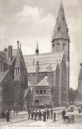
_(5).JPG)
_(3).JPG)