The Churches of Britain and Ireland
|
Romford Churches at
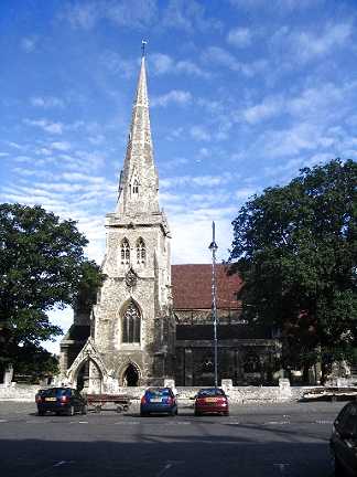
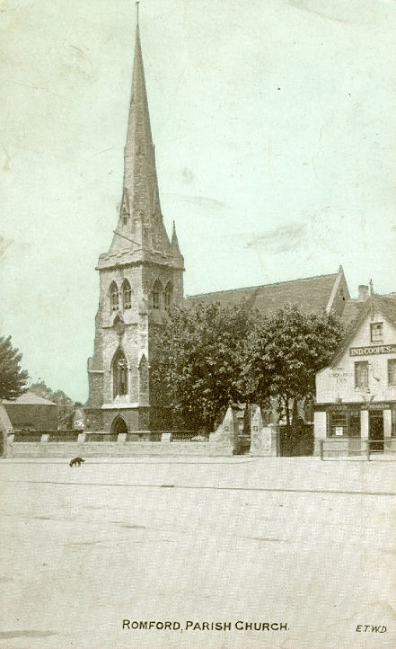
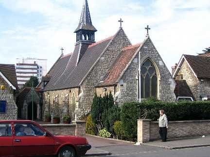
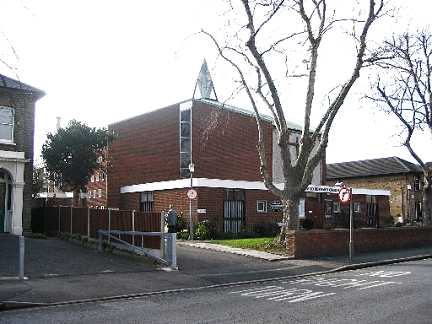
Collier Row. Central Harvest Church on St. Edward's Way, as seen by Streetview in 2024. TQ 5112 8910. Link. Christ Church meets in St. John's Hall, which stands on a site between Pretoria Road and Mawney Road, and was seen by Streetview in 2024. TQ 5013 8911. Link. Church of God in Romford (2022 Streetview) stands on Manor Road. TQ 5226 8875. Link. Church of the Good Shepherd is on Collier Row Lane and Redriff Road - 2022 Streetview. Pevsner gives dates of 1934-5. TQ 5016 9018. Link. Havering Islamic Cultural Centre (2025 Streetview) stands on Waterloo Road. TQ 5114 8829. Link. KICC Romford is on Carlisle Road, and seen by Streetview in 2018. TQ 5203 8864. Facebook. Kingdom Hall of Jehovah's Witnesses is on Brentwood Road, and seen by Streetview in 2024. TQ 5214 8831. KingsHeart Church meets at the Rise Park Centre on Pettits Lane North. It hasn't been seen by Streetview and I haven't been able to find a photo. TQ 5086 9078. Link. The cemetery on Dagenham Road and Crow Lane has a double Mortuary Chapel, centred on TQ 5074 8779. The 25" O.S. map of 1920 labels them as Nonconformist (the more northerly one) and Church of England. The cemetery itself dates from 1871 (source) and presumably the chapels do too. 2025 Streetview. New Testament Church of God on Briar Road, as seen by Streetview in 2025. TQ 5337 9136. Link. Older O.S. maps show a Primitive Methodist Chapel on Victoria Road at TQ 5176 8859. It's dated here to 1875, where it says it was destroyed by bombing in WWII, re-built, and closed in 1966. There are also photos of each chapel. It survives as Victoria Hall, seen by Streetview in 2024. Romford Baptist Church is on Main Road, and seen by Streetview in 2024. TQ 5156 8915. Link. It's dated in a short video on the history page to 1934. Romford & District Synagogue stands on Eastern Road, and was seen by Streetview in 2024. TQ 5157 8865. Link dates the present building to 1956, and mentions earlier synagogues on Eastern Road and on Palm Road in the 1930's. Romford Evangelical Free Church (2022 Streetview) stands on Brentwood Road. There has been a church on the site since at least 1915. TQ 5228 8834. Link. Romford Mosque is on Lessington Avenue, and was seen by Streetview in 2018. TQ 5013 8823. Link. The Romford Quaker Meeting House is on Balgores Crescent. It hasn't been seen by the Streetview van, but there is a good photo of it on their website. How long the website will remain is problematic, as it announces that the final meeting was to be in June of 2025. TQ 5257 8977. St. Agnes (2025 Streetview) on Jutsums Lane is dated here to 1928, where it also says that regular services were last held here in 2017. TQ 4985 8808. St. Alban on Princes Road and King's Road. TQ 5219 8861. © Peter Hobday. Link. The history page dates it to 1890. St. Andrew (2018 Streetview) is on St. Andrew's Road. Its grade II listing dates it to 1862. TQ 5085 8840. Link. St. Edward the Confessor, on Market Place. TQ 5119 8896. © Peter Hobday. An old postcard view, from Reg Dosell's Collection. Link. Grade II* listed. St. Edward the Confessor (R.C.), on Park End Road. TQ 5131 8916. © Peter Hobday. Link. Grade II listed, wherein it's dated to 1856. Salem Baptist Church (2024 Streetview) stands on London Road at TQ 5084 8848. It has a date-stone for 1847. Link. Grade II listed. The Apostolic Church Romford Christian Center stands on Ingrave Road, and was seen by Streetview in 2020. TQ 5104 8923. Link. Trinity Methodist Church (2021 Streetview) stands on Angel Way. Older maps (it pre-dates one of 1898) label it as Wesleyan. TQ 5098 8885. Link. Triumphant Chapel (2025 Streetview), located on Mawney Road, is the former St. John the Divine, dated by Pevsner to 1927. There was still signage for it as St. John at the time of the first Streetview visit in 2008. Subsequent Streetviews show it having signage for The Chapel of Courage (Redeemed Christian Church of God) in 2012-2017, nothing in 2018-19, and the present church from 2020. TQ 5017 8910. TQ Link. U.R.C. on Western Road. TQ 5169 8890. © Peter Hobday. Link.
|
||
12 February 2026
© Steve Bulman
Contact Details