The Churches of Britain and Ireland
|
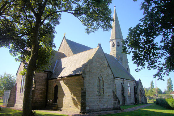
Great Lumley, County Durham
Bethel Methodist Church on Front Street was built as a replacement for the earlier Bethel Chapel listed above. It looks to be of fairly recent construction. NZ 2831 4919. The Streetview van saw it in 2016. Link. The Chapel of Sir John Duck's Hospital was used for some services before Christ Church was built. Erected in 1685, it was demolished in 1960. An illustration of the hospital (but probably not of the chapel) can be seen here. It appears to be based on a photo to be seen here. Its site, and the monument mentioned in this newspaper article, can be seen in a 2009 Streetview. NZ 2896 4916. Christ Church (1859) on Front Street. The church website includes an old engraving. It also mentions services having been held in other venues before the church was built. For these see National School and Chapel of Sir John Duck's Hospital. NZ 2953 4923. © James Murray. An Evangelical Church stands on Scorer's Lane at NZ 2965 4935. A Streetview shows it in 2009. Map evidence tells us that it was preceded by a smaller building on the same site, first showing on a map of 1939 as Hall, and in 1951 as Gospel Hall. Whether the original building was enlarged or re-built is not known, but its appearance today suggests the latter. Link. The National School was used for some services before Christ Church was built. Demolished, it stood at NZ 2888 4916 and the vacant site can be seen in a 2010 Streetview. There was evidently a Primitive Methodist Chapel in the village, as the National Archives website references documents pertaining to its sale in the mid-1930's, but its location is so far undetermined. The former West End Methodist Church stands off Front Street at NZ 2905 4920, and is now in residential use. Originally Wesleyan, it pre-dates the O.S. map of 1898. It can be seen on a 2010 Streetview.
|
||
04 March 2023
© Steve Bulman