The Churches of Britain and Ireland
|
Bray, County Wicklow
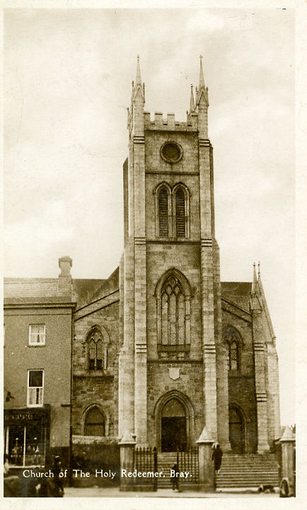
Bray Methodist Church stands at the corner of Florence Road and Eglinton Road, and was seen by Streetview in 2023. Its Wikipedia entry dates it to 1864. O 2657 1864. Link. Christ Church on Church Road. O 2620 1792. From an old postcard in Steve Bulman's Collection. Link1. Link2. Previously in the "Unknown" Section, this old postcard (from Reg Dosell's Collection) is clearly labelled Church of the Holy Redeemer, Bray. I thought this was probably the Bray in County Wicklow, since it has a church of the same name, though different appearance. This source (with photos, and which dates the church originally to 1858) says the church was given a new facade sometime in the 20th century. And Janet Gimber has confirmed that this is the correct identification. O 2631 1865. Link. Cornerstone Church at the Well (2025 Streetview) stands off Main Street at O 2633 1880. According to this source it was originally St. Paul's, 1609-1987 (though the present building "largely of 1911 rebuild"), subsequently in secular use until taken over by the current church. Link. The Kingdom Hall of Jehovah's Witnesses stands on O'Byrne Road, and was seen by Streetview in 2022. O 2645 1729. A former Methodist Chapel stands on Parnell Road, at O 2625 1843. Seemingly built in the early 1840's,it'snow in commercial use and was seen by the Streetview van in 2023. Our Lady Queen of Peace (R.C.) on Vevay Way - 2022 Streetview. O 2674 1750. Link, has photos and videos. This page says it's celebrating 80 years in 2026. Just beyond the outskirts of the town are the remains of Raheen-A-Cluig Chapel, O 2767 1760. It can't be seen on Streetview, but photos can be seen here, where it's dated to the 12th or 13th century. St. Andrew (Presbyterian) on Quinsborough Road and Eglinton Road, as seen by Streetview in 2022. O 2655 1876. Link. St. Brigid (CoI, 2025 Streetview) on the E01 and Herbert Road, Kilbride. Link - dates it to 1857-9. St. Fergal (R.C., 2024 Streetview) on Lillarney Road and Boghall Road, Ballymorris. O 2535 1699. Link - dates it to 1980, "to replace the Nissen Hut church/school on Boghall Road". A photo of the old church, and of another temporary church, can be seen here. St. Mary and St. Demyana (Coptic Orthodox) on The Pines, as seen by Streetview in 2009.O 2540 1777. St. Peter (R.C., 2009 Streetview), off Chapel Lane in Little Bray. O 2588 1925. Link.
A map of 1840 shows
Zion Chapel on Killarney Road at O 2632 1856. It's no longer
labelled on a map revised no later than 1909, so had presumably been
closed or demolished by that date. A shop stands on its site today -
2025 Streetview.
|
||
12 June 2026
© Steve Bulman
Contact Details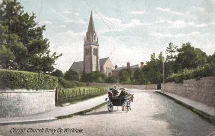