The Churches of Britain and Ireland
| Bedlington,
Northumberland
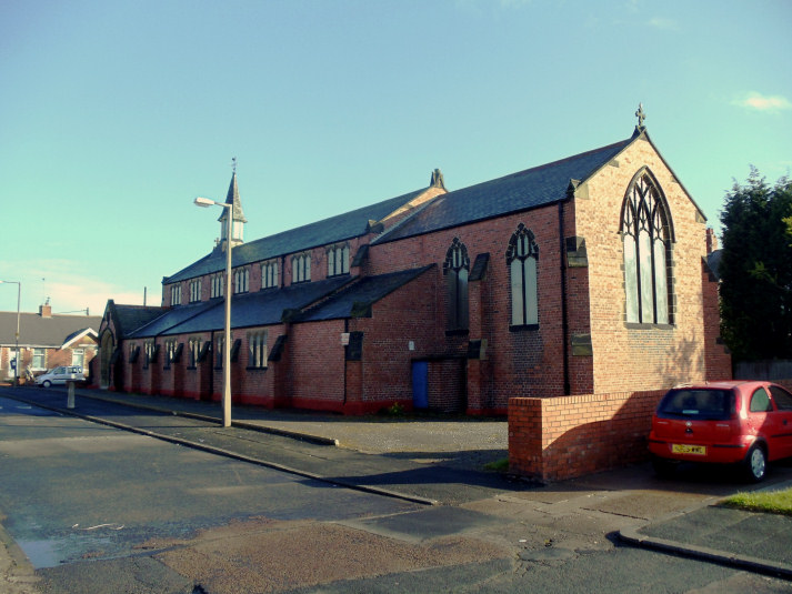
Bedlington Colliery Methodist Church on Station Road, as seen by Streetview in 2018. It's marked on older maps as Wesleyan, and pre-dates a map of 1897. NZ 2746 8281. Link. Bedlington Christian Fellowshop on Vulcan Place is marked on old maps as Meth. Chapel (F.U.) - Free United Methodist. NZ 2621 8202. It was seen by Streetview in 2009, and is notable for its frontage following the curve in the road. Link. The 25" O.S. map of 1892-1914 shows a Christians Meeting House. NZ 2572 8192. It's first shown unambiguously on a map of 1897. A later map of 1959 labels it as Church of Christ (Noncon.). It seems to have survived as a place of worship at least into the 1980's. It stood towards the left end of the terrace of commercial properties, seen here in a Streetview from 2008. Hope Church meets in the East Bedlington Community Centre on Station Street, Bedlington Station. It can be seen on a Streetview from 2020. Link. Kingdom Hall of Jehovah's Witnesses on Stead Lane, as seen by Streetview in 2009. The cemetery on Netherton Lane used to have a Mortuary Chapel, at NZ 2492 8200. It stood just to the left of the cemetery entrance, seen here on a Streetview from 2009. A Primitive Methodist Chapel on Clayton Street is first shown on a map of 1922, and seems to have survived as a Methodist Church into the 1980's at least. Its site (I think it's been demolished) hasn't been seen by Streetview, and I haven't been able to find a photo of it. NZ 2768 8303. Another P.M. Chapel stood on West End Front Street at NZ 2582 8192. Built in the mid-1890's, it was still active as a place of worship into the 1980's at least. It can be seen on a Streetview from 2020. The Catholic Church in Bedlington is St. Bede, on Catholic Row. Seen here in a Streetview from 2009, it's evidently a fairly recent build, and what must be its predecessor stands a little way along the same street, seen here also in 2009. It can be dated fairly closely from old maps to 1895-7. Link. St. Cuthbert stands on Church Lane and the A193. It was seen by Streetview in 2020. NZ 2605 8182. Link. Grade II* listed. St. John, Sleekburn, at Bedlington Station. NZ 2783 8312. © Bill Henderson (2012). Link. Trinity Church (Methodist and U.R.C) on West End Front Street and Clovelly Gardens, at NZ 2568 8192. It's marked on older maps as a Presbyterian Church, and on a map of 1959 as Dall Memorial Presbyterian Church of England. It can be seen on a 2020 Streetview. Link. A United Presbyterian Chapel can be seen on the 25" O.S. map of 1892-1914, at NZ 2678 8176 on Old Colliery Row. Demolished, its site (Streetview 2009) lies under the road (Bell's Place), about level with the nearest house on the left. A Wesleyan Methodist Chapel once stood on Chapel Row, at NZ 2638 8165. Chapel, and even Chapel Row are both gone, and its site lies about half way along the patch of grass seen here on a Streetview from 2009, from Hollymount Avenue.
|
||
28 August 2006
© Steve Bulman