The Churches of Britain and Ireland
| Beckenham, Greater London
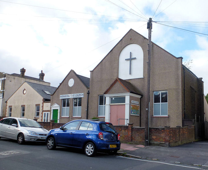
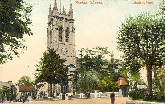
Avenue Baptist Church on Avenue Road. TQ 3568 6948. © Janet Gimber (2016). Link. Beckenham Baptist Church on Beckenham Road and Elm Road, as seen by Streetview in 2024. Pevsner dates it to 1889. TQ 3662 6949. Link. Beckenham Methodist Church (2025 Streetview) is on Bromley Road and Bevington Road. It's dated in Pevsner to 1887 - it also says that it used to have a spire. Older O.S. maps label it as Wesleyan. TQ 3756 6951. Link. Beckenham U.R.C. (2025 Streetview) on Crescent Road and Oakhill Road was originally Congregational. Pevsner dates it to 1887-8. TQ 3800 6923. Christ Church (2025 Streetview) is on Fairfield Road and Lea Road. TQ 3734 6939. Link. Immediately adjacent to Beckenham U.R.C. (see above) on Oakhill Road is Church of God 7th Day (Sabbath Keeping) - 2025 Streetview. TQ 3803 6921. Link. Citygate Church is on Rectory Road, and seen by Streetview in 2025. TQ 3697 6946. Link. Elmers End Free Church U.R.C. (2025 Streetview) is on Goddard Road, at TQ 3596 6831. It stands back to back with what must be its predecessor which fronts onto Langley Road (2025 Streetview). Labelled on older maps as Congregational, old maps show it to have been built between 1867 and 1896. TQ 3599 6832. The Our Story page on the church website dates the first church to 1884, and its successor to 1931. Grace Church meets in a school on St. George's Road, and was seen by Streetview in 2025. TQ 3754 6962. Link. Holy Trinity stands at the junction of Lennard Road and Cator Road, at TQ 3578 7066. Dated by Pevsner to 1878, with the spire added a few years later. It was seen by Streetview in 2025. Link. Shown on old O.S. maps a little way west is Holy Trinity Mission House, at the corner of Mosslea Road and Trinity (now Station) Road, at TQ 3531 7069. The 2025 Streetview shows its date of 1887. Hope Community Beckenham Seventh-Day Adventist Church on Churchfields Road, as seen by Streetview in 2025. TQ 3612 6946. According to older O.S. maps, it was, or stands on the site of, a Mission Hall, built between 1863 and 1895 (perhaps 1885, see the entry for St. Augustine, below). Link. Kingsway Church (2025 Streetview) is on Rectory Road. TQ 3697 6951. Link. The cemetery on Elmers End Road used to have two Mortuary Chapels, showing on O.S. maps at TQ 3528 6885 (Church of England) and TQ 3532 6879 (Nonconformist). Only the latter survives (Google Maps image), the other having been destroyed by bombing in in WWII (source). Neighbourhood Church (2020 Streetview) stands at the junction of Colesburg Road and Cromwell Road, at TQ 3653 6892. Link. The former St. Augustine (2025 Streetview) on Churchfields Road has been converted into flats. This source provides dates of 1910-1978, and says it replaced a Mission Hall of 1885. In all likelihood this is the the building (or site) in the entry above for Hope Community 7-DA Church, above. St. Barnabas on Oakhill Road, as seen by Streetview in 2025. TQ 3817 6916. Link. St. Edmund (R.C.) on Village Way, as seen by Streetview in 2025. TQ 3714 6928. Link. The About Us page dates it to 1937-8. Its predecessor was dedicated as Transfiguration and St Benedict, which stood on Overbury Avenue, which the source already given dates to 1892. Flats now stand on its site - 2012 Streetview. TQ 3810 6898. St. George on High Street, Bromley Road and St. George's Road. It's dated in Pevsner to 1885-7 (tower added 1902-3) replacing a medieval church - some illustrations and photos of which can be seen here. TQ 3748 6965. From an old postcard (franked 1905), in Dave Westrap's Collection. A 2021 Streetview provides a modern view. Link. Grade II* listed. Its lych-gate is also listed, at grade II, which says it's the oldest surviving example in England, dating from the 13th century. St. John is on Eden Park Avenue, seen by Streetview in 2025. TQ 3738 6786. Link. St. Michael and All Angels (2025 Streetview) on Ravenscroft Road. TQ 3559 6944. Link says it dates from 1956, on the site of a predecessor destroyed by WWII bombing. This shows on earlier maps, set well back on the site, at TQ 3561 6941. Perhaps fronting onto Birkbeck Road, housing now stands on the site, seen by Streetview in 2025. St. Paul is on Brackley Road and Lawn Road, and was seen by Streetview in 2025. Its grade II listing dates it to 1868-72. TQ 3699 7041. Link. The Excel Church meets at a Langley Park School (2021 Streetview) on Hawksbrook Lane. Link.
|
||
12 January 2026
© Steve Bulman