The Churches of Britain and Ireland
| Basingstoke, Hampshire
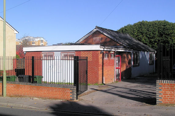
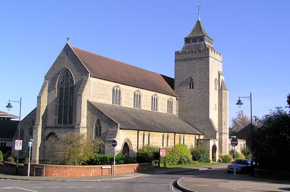
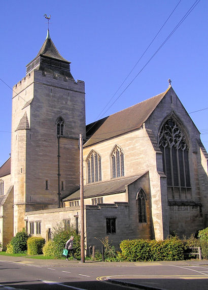
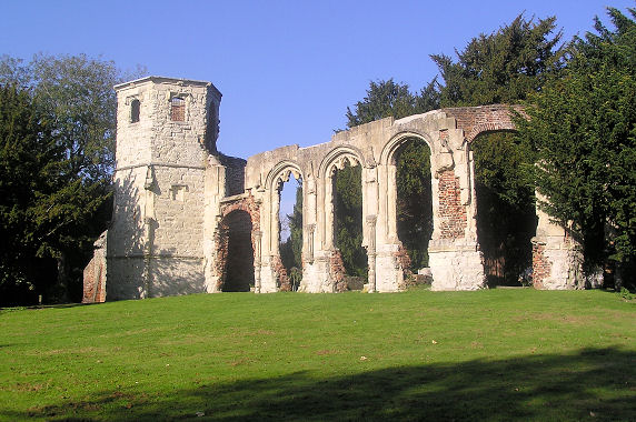
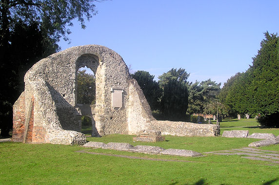
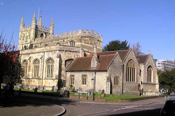
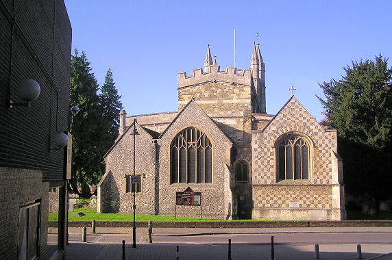
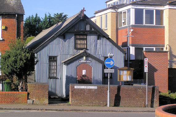
Albirr Mosque on Sarum Hill. © Mike Rice. It fell victim to an arson attack in 2006 (BBC news story). As of 2025 the mosque has evidently been repaired or re-built (Streetview). All Saints on Southern Road and Victoria Street. Its grade II listing dates it to 1915, by Temple Moore. Another view. SU 6371 5169. Both © Mike Rice. Link. A Baptist Chapel used to stand set well back on Church Street. SU 6377 5200. It shows on a map of 1873, but had gone no later than the late 1950's. Its entrance was about where the car is (facing the camera) in a Streetview from 2017. There are presently two Baptist Church in Basingstoke, the first is Basingstoke Baptist Church on Gershwin Road, seen by Streetview in 2023. SU 6145 4989. Link. The other is West Basingstoke Baptist Church on Brighton Hill, seen by Streetview in 2024. SU 6203 4994. Link. Buckskin Evangelical Church stands on Chiltern Way - 2025 Streetview. SU 6067 5171. Link. The ruins of the Chapel of the Holy Ghost, which stands within the cemetery on Chapel Hill. SU 6358 5262. © Mike Rice. Grade II* listed. The cemetery used to have two Mortuary Chapels, at SU 6353 5267 (CoE)and SU 6361 5268 (nonconformist), but neither has survived. Ruins of the Chapel of the Holy Trinity. Both this chapel, and the Holy Ghost Chapel (above) are in South View Cemetery. SU 6358 5262. © Mike Rice. Grade II* listed. Christ the King on Brighton Hill, as seen by Streetview in 2021. SU 6201 4989. Link. Church of Jesus Christ of Latter-day Saints (2025 Streetview) on Carpenters Down and Crockford Lane. SU 6487 5443. Church of the Good Shepherd on Winklebury Way and Winklebury Centre, as seen by Streetview in 2023. SU 6120 5244. Link. Pre-dating a map of 1896 is a Congregational Chapel on Worting Road. Still active in the mid-20th century, it's now in commercial use - 2025 Streetview. SU 6063 5181. There used to be a Friends' Meeting House on Wote Street, at SU 6383 5210. Pre-dating a map of 1873, it hasn't survived. Its site hasn't been seen by Streetview, but aerial views show it to have stood where the car park is now, behind Beaverbrooks jewellers. The present Friends' Meeting House is on Fairfield Road - 2025 Streetview. SU 6380 5151. Link. God With Us Church meets in Everest Community Hall (entrance to the site, 2025 Streetview) on Oxford Way. SU 631 544. Facebook. Harvest Chapel International (2024 Streetview) is on Kempshott Lane. It may have just taken possession recently, as the church has signage for Kempshott Methodist Church (Streetview). A map revised no later than 1930 labels it as Meth. Ch. A 2024 news article records its closure, and dates it originally to 1912, replaced in the 1960's behind the earlier site. SU 6024 5046. Link. Healing Springs Church meets in Viables Community Association on on The Harrow Way, seen by Streetview in 2017. SU 6311 5026. Link. Holy Ghost (R.C.) on Sherborne Road and Burgess Road, as seen by Streetview in 2025. SU 6342 5275. Link - dates its consecration to 1902. Grade II listed, as is the adjacent presbytery. Hope Community Church (2025 Streetview) is on Sarum Hill at SU 6346 5191. Link. A Lady Huntingdon's Chapel shows on a map of 1873 on Wote Street at SU 6385 5200. Never labelled on later available maps, it seems to have survived (presumably as Methodist) up to the 1950's, but has since been demolished and replaced by some shops, seen by Streetview in 2017. A photo of the chapel can be seen here, where it's named as Immanuel (Countess of Huntingdon’s Connexion) Church. London Street U.R.C. The Rev. John Curwen, who has a place in the history of music, was minister here for a while. SU 6390 5189. © Mike Rice. Link. Melrose Christian Fellowship meets in Melrose Community Hall (2025 Streetview) on Abbey Road. SU 6352 5394. Link. A map of 1896 shows a Mission Room on May Street, at SU 6309 5230. Its site now lies beneath the Churchill Way West, roughly where the car is in a Streetview from 2025. There was also a Mission Hall, showing on a map of 1932 at the corner of George Street with Deep Lane. It's been replaced by the house seen in a Streetview in 2023. SU 6274 5214. Mosaic Church (2025 Streetview) on Wade Road. SU 6528 5354. Link. Praise Embassy Church meets in Lennox House on Lennox Road, which was seen by Streetview in 2023. SU 6248 5059. Link. A Primitive Methodist Chapel used to stand set back from Flaxfield Road, near its eastern end. According to this source (which includes an old photo of the chapel) it dated from 1847, closing in 1902 (when they moved to Sarum Hill), and demolished circa 2006. Its site was seen by Streetview in 2025. SU 6364 5198. The Sarum Hill P.M. Chapel stood at circa SU 6354 5187, and its demolition is given here (where there are photos) to the 1960's. Its site was also seen by Streetview in 2025. The Salvation Army Church (2015 Streetview) is on Wessex Close. SU 6314 5135. Link. One of their earlier premises shows on a map of 1896 as Salvation Army Barracks, on Reading Road at SU 6400 5248. A later map labels it as S.A. Hall. The roads layout has changed completely - its site now lies partly beneath St. Clement House and partly beneath Alençon Way, seen by Streetview in 2025. St. Andrew's Trinity Methodist Church (2025 Streetview) on Western Way and Pinkerton Road. SU 6197 5116. It was originally just St. Andrew, changing its dedication on the closure of Trinity Methodist on Sarum Hill (2025 Streetview). SU 6350 5190. Link. St. Bede (R.C.) on Popley Way, as seen by Streetview in 2016. SU 6348 5426. Link. St. Gabriel (2025 Streetview) on Tewkesbury Close. SU 6372 5422. Link. St. Mark on Homesteads Road - 2012 Streetview. SU 6059 4979. Link - dates it to 1986-7. St. Mary on Eastrop Lane and Goat Lane, as seen by Streetview in 2021. SU 6414 5218. Link. Grade II listed. St. Michael on Church Lane. Another view. SU 6366 5219. Both © Mike Rice. Link. St. Thomas of Canterbury (or St. Thomas a Becket), on Worting Road. Another view. SU 6007 5180. Both © Karel Kuča (2025). Link. Grade II listed, wherein it's dated to 1848. The Seventh-day Adventist Church has recently moved into the former Trinity Methodist Church on Sarum Hill, for which see above the St Andrew's Trinity Methodist Church entry above. The church had previously met in Melrose Community Centre in Popley, presumably the same building as used by Melrose Christian Fellowship (see above). Link. Spiritualist Church on Victoria Street. SU 6366 5166. © Mike Rice. Link. Wessex Christian Fellowship (2025 Streetview) on Wessex Close. SU 6303 5126. Link
|
||
23 January 2026
© Steve Bulman