The Churches of Britain and Ireland
| Ancoats, Manchester, Greater Manchester
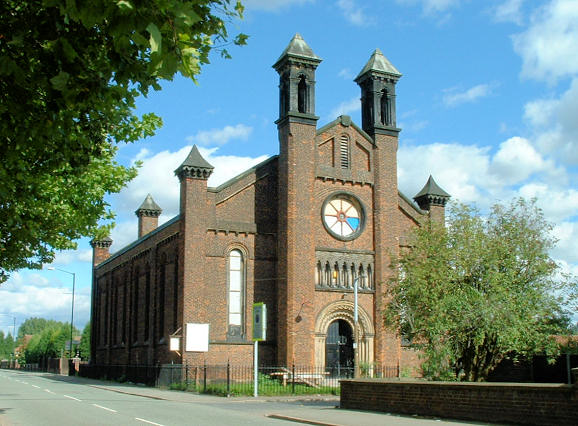
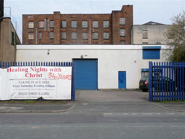
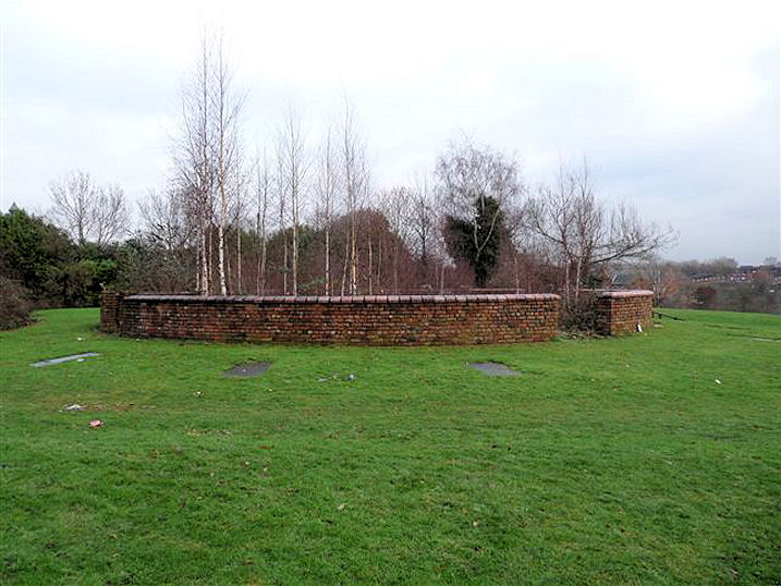
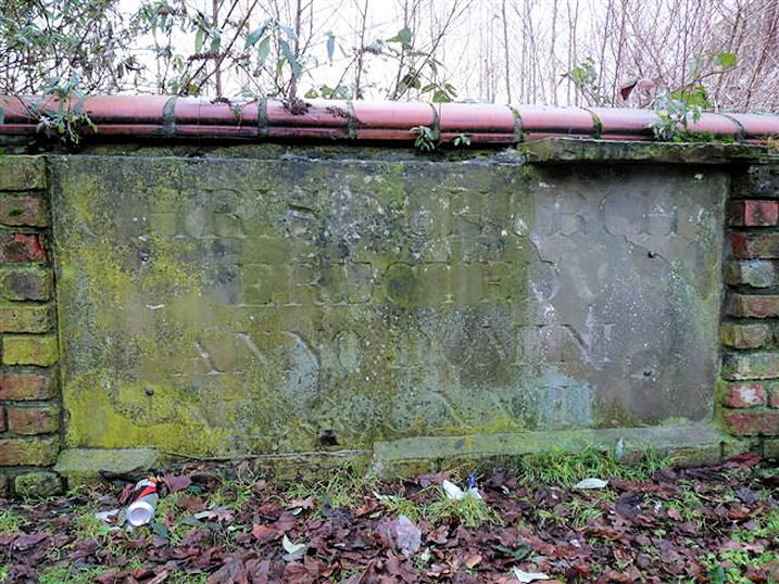
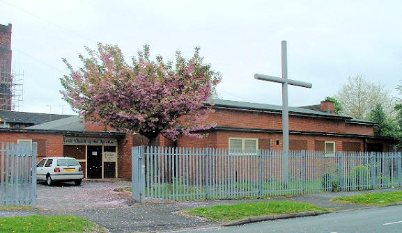
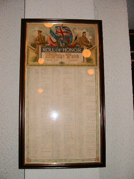
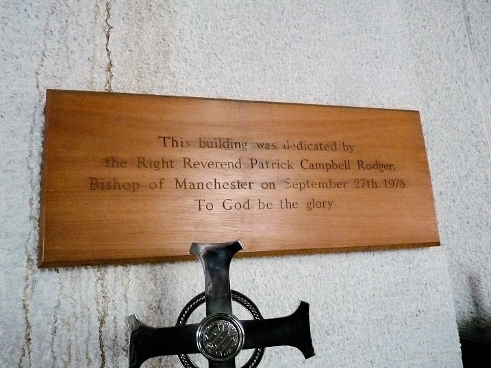
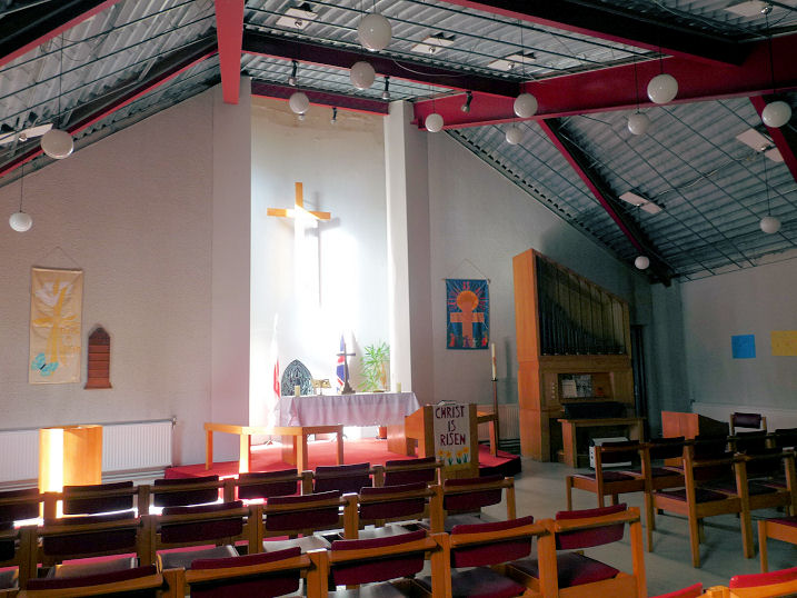
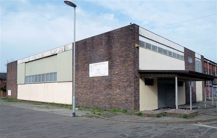
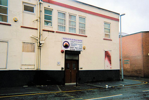
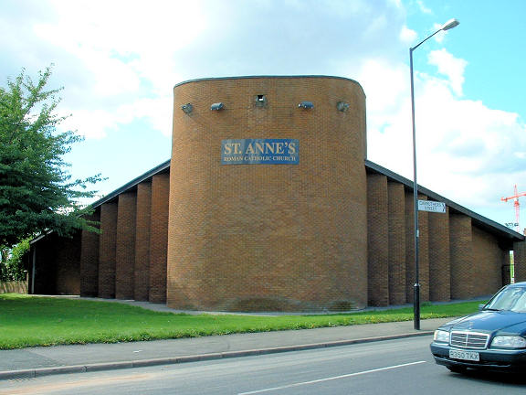
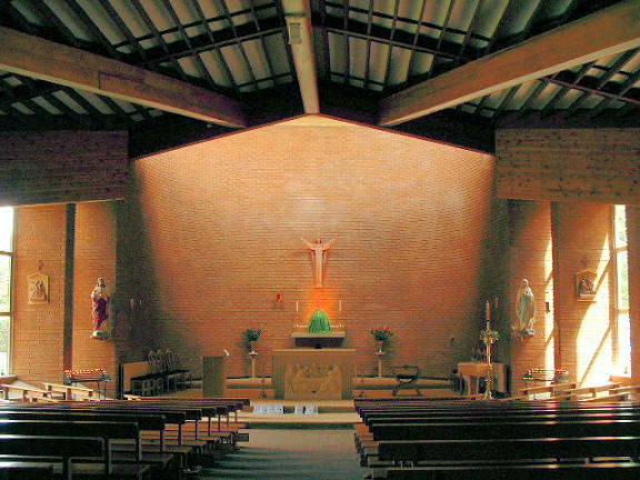
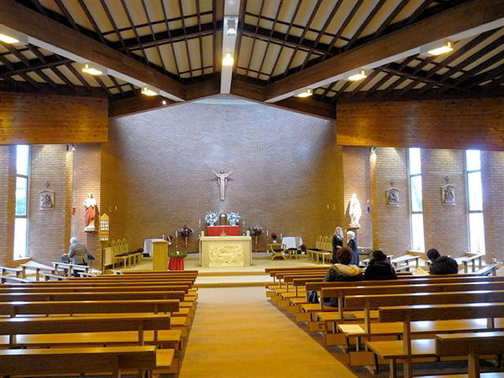
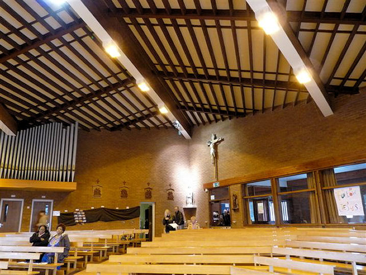
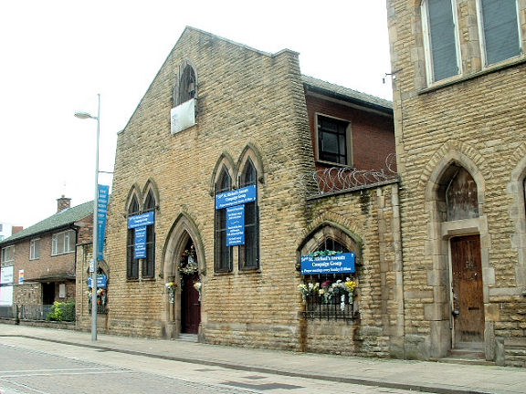
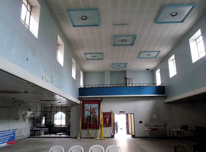
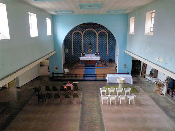
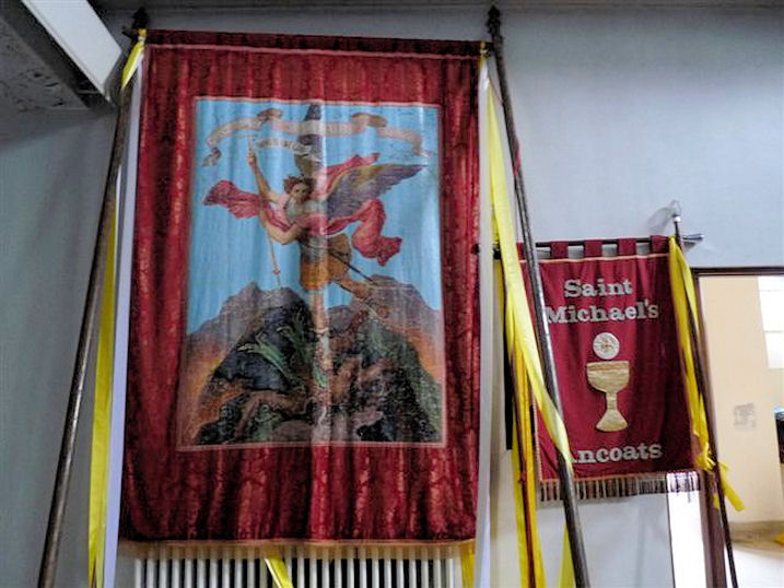
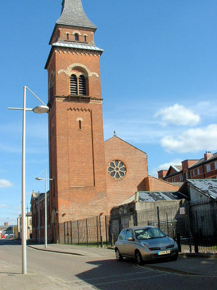
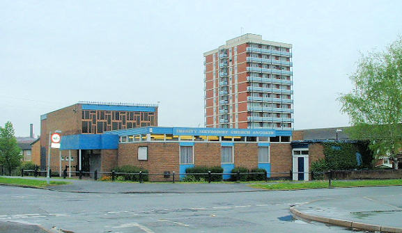
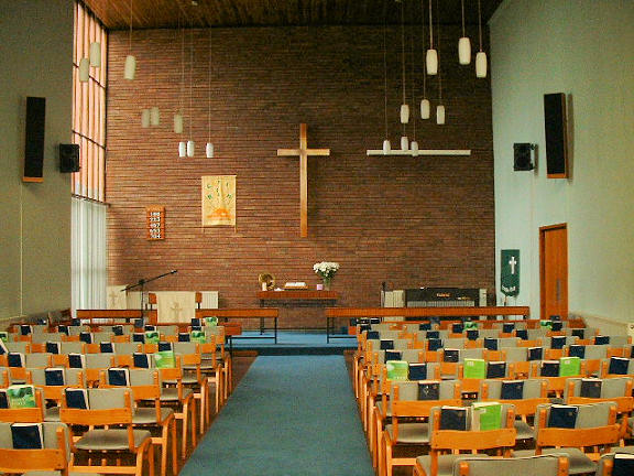
All Souls on Every Street and Harding Street. SJ 8579 9820. Currently undergoing renovation; re-opening planned for late 2006 as Manchester United Church, a part of the Mount Zion Restoration Ministries. © Mike Berrell. Did the re-opening ever happen? As of 2021 the building looks derelict - 2021 Streetview. Body of Christ International Ministries on Pollard Street. SJ 8578 9855. © Mike Berrell (2010). At some point before 2017, the church had closed or moved elsewhere, as a Streetview from that year shows the building in commercial use. Chalmers Presbyterian Church is mentioned here as standing on Piercy Street and Mill Street, and it's dated to 1837-1917. A 6" map of 1909 shows a Ch. at SU 8568 9860, and a map of 1922 (revised in 1915) shows it as a "Picture Theatre", though of course it may have been built on the site of the church. In this Streetview from 2023 the left end of the terraced housing stands on the site of the church, which was aligned at 90 degrees to the terrrace. The site of Christ Church Chapel (Bible Christian, aka Round House Chapel) on Every Street, which was opened in 1855 and closed in 1880. There's an old photo here. Foundation stone built into the wall. SJ 8570 9807. Both © Mike Berrell (2010). Link. A Christian Brethren Chapel is mentioned here as having stood on Walter Street, active from before 1895. No available maps show it, and the area has been completely redeveloped. However, almost all of Walter Street now lies below a large office block on St. Andrew's Square and Travis Street, seen here in a Streetview from 2023. Church of The Apostles on Ridgway Street. Roll of Honour, which formerly hung in the now demolished St. Philip's parish church (for which, see below). SJ 8579 9879. Both © Mike Berrell. The church was dedicated in 1978 (plaque). Interior view. Both © Mike Berrell (2018). A map of 1891 shows a Congregational Church at the northern end of Every Street and Mitchell Street (now Merrill Street). SJ 8596 9844. It's dated here to 1870-1967 (by which time it was perhaps U.R.C.). It's site remains undeveloped, and was seen by Streetview in 2023. This source mentions Jersey Street Baptist Chapel (1845-?), precise location unknown. I can only find one place of worship on Jersey Street on any of the available maps - a Primitive Methodist Chapel (for which see Jersey Street Primitive Methodist Chapel below). The location of Jersey Street Baptist Chapel must remain unknown until more information become available. Jersey Street Primitive Methodist Chapel used to stand on the corner of Jersey and Henry Streets, at SJ 8490 9859. It's mentioned here as having been built in 1823. Lees Street Welsh Calvinistic Methodist Chapel stood at the corner of Lees Street (now Laystall Street) and Bank Street (now Brock Street). SJ 8499 9830. Short-lived, it's dated here to 1830-1849. The building on the site today - (office or flats)? - was seen by Streetview in 2020. Manchester Christian College and Assembly on Chippenham Road and Old Mill Street. SJ 8559 9859. © Mike Berrell (2010). As of 2023, Google Maps is showing this as The Rulers Church. Facebook. A Methodist Association Chapel is listed here on Great Ancoats Street, with dates 1836-1900. At the dates of available maps it should be labelled as a Methodist Association (before 1857), United Methodist Free Church (following the merging of several strands of Methodism in 1857, and up to 1907, when another merger gave rise to the United Methodist Church), however none of these is apparent. My best guess is that the chapel was one shown on a map of 1851 as Ancoats Chapel (Wesleyan Methodist), and as Wesley Hall in 1908. It stood on the south side of Great Ancoats Street, bounded on its north side by Wesley Street, and on the south by Adair Street. The building on the site today was seen by Streetview in 2022. SJ 8535 9805. A Methodist Church is listed here on Canal Street as Tent Methodist Chapel, of 1820-37. No available maps show it, and Canal Street no longer exists. A map of 1851 shows a Methodist New Connexion Chapel on Piercy Street and Carruthers Street at SJ 8560 9853. The label also appends that the chapel was on the upper storey. It had a relatively short life, dated here to 1846-66. The housing built on the site was seen by Streetview in 2023. Mountain of Fire and Miracles Ministries (in a former clothing factory), on Bendix Street and Hatter Street. SJ 8466 9898. © Rob Brettle. Since Rob took his photo, the buildings on the block have been demolished, and this high-rise was being built in 2020 (Streetview). A map of 1891 shows a Primitive Methodist Chapel on New Islington and Baker Street (which no longer exists), at SJ 8533 9863. It's described here as having been built in 1874, whereupon the Jersey Street P. M. Chapel (see above) and Great Ancoats Street P.M. congregations joined together here, and closed their old chapels. The site today is covered by the small garden and the adjacent buildings, seen here in a Streetview from 2023. A photo of the church can be seen here. St. Alban (R.C.) stood on Fawcett Street and St. Thomas Street, a little way east of St. James the Less, at SJ 8509 9841. These streets no longer exist. They stood east of Ring Road - the church site can be seen here, in the middle distance behind the traffic light, in a Streetview from 2020. It's dated here to 1863-1970. The site (car park) of the demolished St. Andrew, on St. Andrew's Square, seen by Streetview in 2023. A photo of the church can be seen here. SJ 8527 9787. St. Anne (R.C.) on Carruthers Street (was earlier Junction Street). Interior view. SJ 8578 9830. Both © Mike Berrell. Two more interior views, 1, 2, both © Mike Berrell (2011). Link. The history here gives a building date of 1977-8, when it replaced an earlier church of 1848. I haven't been able to find a photo of the old church. The site of the demolished St. James the Less on Little Newton Street. Its dates are given here as 1870-1937. Even the street has gone. The site can be seen from Ring Road, roughly centrally in this view (2021 Streetview). SJ 8503 9839. St. Joseph (R.C.) is noted here on Goulden Street, location uncertain, and dated to 1852-1904. A map of 1891 shows it at the corner of Goulden Street and Mason Street at SJ 8463 9895. The office block on its site was seen by Streetview in 2020. St. Jude used to stand on Mill Street and Kirby Street. Kirby Street has gone, and Mill Street is now Old Mill Street. A 1953 photo showing the church can be seen here. The church had been demolished before the first Streetview visit in 2012. The building on its site was seen by Streetview in 2023. SJ 8544 9846. This source mentions a St. Martin's Church, exact location unknown, but on Radium Street (earlier German Street); dates 1873-1905. The 6" O.S. map of 1909 shows a black square (the usual sign of places of worship and schools) on German Street and Silk Street, at SJ 8501 9886. Assuming this was St. Martin, the site had been cleared before the first Streetview visit in 2008. An office block had been built by 2023. St. Michael (R.C.) on George Leigh Street. The official dates are 1869-2004, though a sign still announces a Sunday Prayer Group. SJ 8486 9870. © Mike Berrell. Three interior views - 1, 2, 3, and a processional flag, all © Mike Berrell (2011). Link. The former St. Peter, dating from 1859, on Blossom Street. In secular use since 1960, it is currently being restored. SJ 8496 9868. © Mike Berrell. Mike advises (2013) that it is now known as Hallé St. Peter's - see here. The site of the demolished St. Philip on Ridgway Street and St. Philip's Street, as seen by Streetview in 2023. It was consecrated in 1850, and demolished circa 1967. SJ 8576 9878. I haven't been able to find a photo. Trinity Methodist Church (1964) on Butler Street. Interior view. SJ 8562 9875. © Mike Berrell. Link. A United Methodist Chapel shows on old maps at the junction of Beswick Street and Bradford Road at SJ 8573 9865. It's dated here to "before 1871". It was still standing in 2017 (Streetview), but has since been mostly demolished (2023 Streetview).
|
||
02 January 2024
© Steve Bulman