The Churches of Britain and Ireland
|
Seaham or Seaham Harbour, County Durham My appreciation to Howard Richter
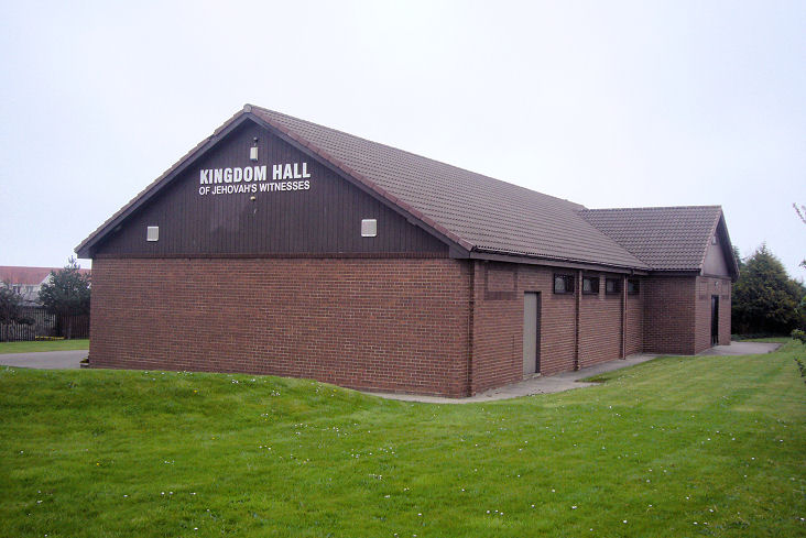
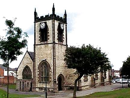
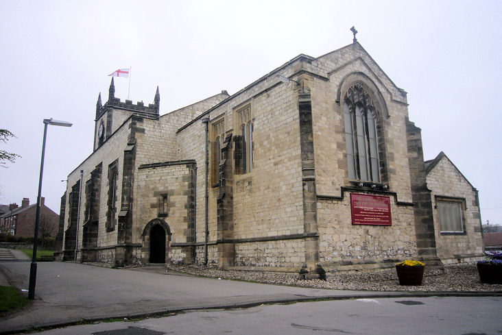
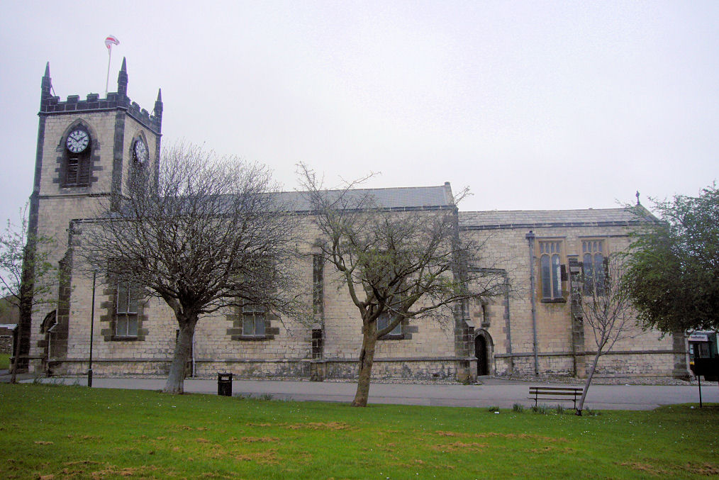
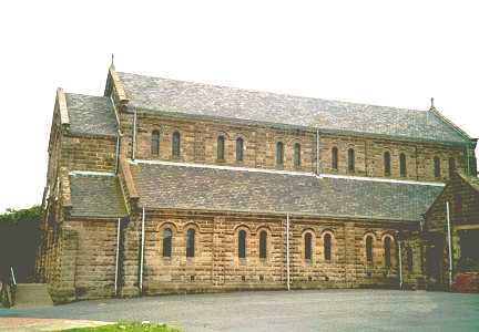
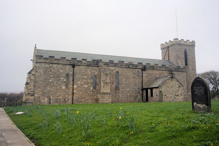
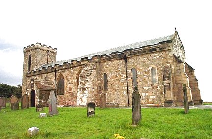
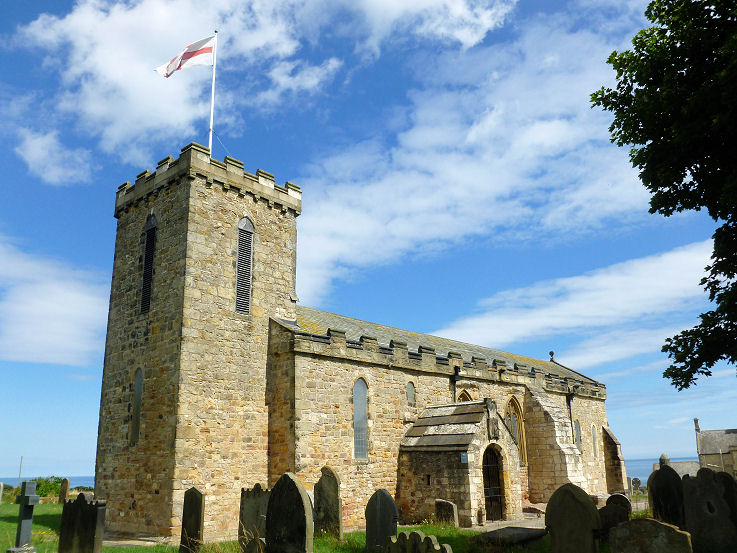
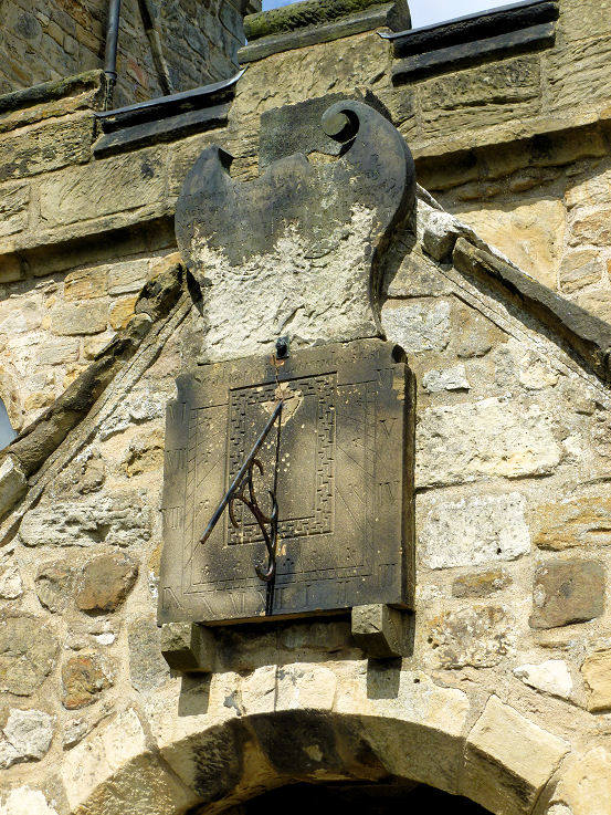
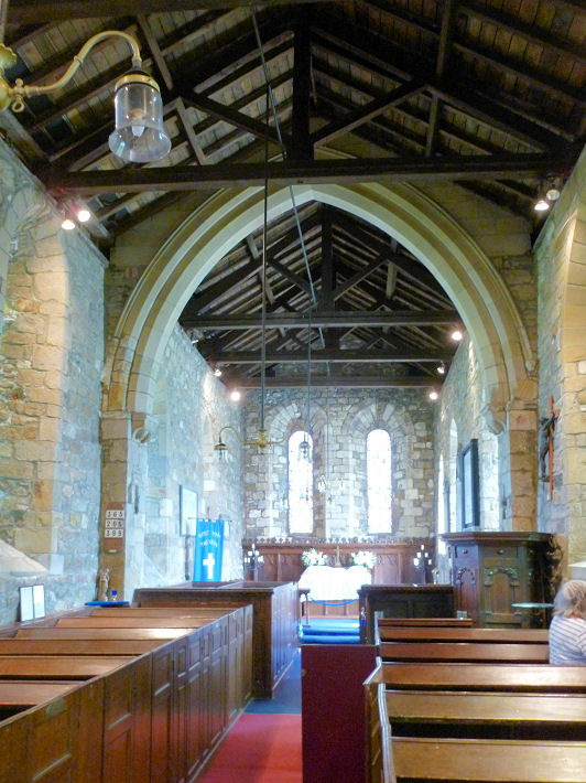
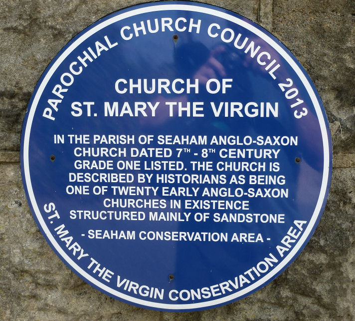
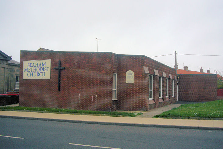
for his researches into many of the churches listed hereunder. All Saints at Deneside can be seen here in a 2012 Streetview. Built in the late 1960's (ref.), it was preceded by a Mission Church of 1932 which stood a few yards south of the present church. Photo of the exterior and interior of the Mission Church are available here - show thumbnails, select page 2, and they are the 3rd and 4th photo in the top row. NZ 4147 4905. Bourne Primitive Methodist Church stood on Tempest Place at NZ 4288 4967. Dates from here of building (1850), re-built in 1871. It collapsed in 2002 and was subsequently demolished. Streetview shows a brick-built building on the site. The chapel was beneath the nearer half of the block. Centenary Primitive Methodist Chapel stood on Stewart Street at NZ 4316 4885. Built in 1910, it was later in industrial use, and later as a Scout HQ. It was demolished in 2002. A photo is available here, and a 2009 Streetview shows the bungalows built on the site. Christ Church (1857) at New Seaham. 2018 Streetview. NZ 411 498. © Bill Henderson. Grade II listed. A former(?) Gospel Hall stands on Harbour Walk near the catholic St. Mary's. NZ 4214 4952. It can be seen on a 2012 Streetview. An Independent Methodist once stood on Caroline Street at NZ 4280 4925. It shows on maps of 1939 to the 1967-76 edition. Another Independent Methodist church stands on Enfield Road at NZ 4091 4946. Built in 1886, it's still active, and a photo is available here. Jubilee Primitive Methodist Chapel stood on Eastlea Road at NZ 4093 5944. Built in 1877, it continued in use until at least as recently as the mid-1990's, and survived at least until 2009, when Streeview was passing. Kingdom Hall of Jehovah's Witnesses on New Strangford Road. NZ 4207 4936. © James Murray. A Streetview of 2018. The former Lighthouse Christian Centre (Pentecostal) stands on the corner of Charles Street and Emily Street, and it can be seen on a 2012 Streetview. Originally built as a school, it became a "Cookery Centre" around the late 1930's or early 1940's, up until circa 1980. The LCC used the building subsequently, until no later than 2009, from when a news report mentions that the church had sold this property, and had moved to St. Hild and St. Helen at Dawdon (for which, see below). A Methodist Mission Chapel once stood on Ash Crescent, the predecessor of Parkside Methodist Church (for which see below). It's shown on a map of 1956, and it evidently had a short life, as it had been demolished and replaced by a different building (marked as Club) by the time of the 1967-79 edition. What is probably the same building can be seen on a 2012 Streetview. NZ 4236 4895. A Mission Hall once stood on Westlea Road at NZ 4080 4904. Showing on maps from just after WW1, a health centre stands on the site today - seen in a 2016 Streetview here. A Mission Room once stood on Queen Alexandra Road at NZ 42810 4855. Originally a school, (as shown on a map of 1897), a map of 1919-20 shows it as Mission Room. It continued as such until the final map which shows it on the edition of 1979-80, but on the following map of 1987 it is no longer labelled, and the footprint may have changed. The site of the church can be seen here on Streetview, a more modern building being in use by an undertaker. Parkside Methodist Church (1962) stands at NZ 4227 4824. A Streetview of 2009 is available here. A Presbyterian Church once stood on Adolphus Street. Built in 1882, it was destroyed by bombing in 1943. A photo is available here. The building on the site today is in use by the Girl Guides, and can be seen on a 2018 Streetview here. NZ 4273 4921. Link. Princess Road Cemetery has two mortuary chapels, showing as Church of England and Nonconformist on a map of 1897. One of them can be glimpsed through the trees on a 2012 Streetview. NZ 4249 4892. Link. St. Cuthbert (R.C., 1965) stands on Mill Road at NZ 4070 4984. A photo is available here, and a 2012 Streetview here. It was preceded by St. Cuthbert's Church Hall, active from 1934, which stood at NZ 4065 4989, a little way north of the present-day church. The site, vacant in 2016, can be seen on Streetview here; housing has since been built on the site. St. Hild and St. Helen (1912) stands on the corner of Mount Stewart Street and Melbury Street, Dawdon. A 2009 Streetview. See also the entry for Lighthouse Christian Centre, above. NZ 4295 4830. Grade II listed. St. John the Evangelist on Church Street. NZ 42704933. © Bill Henderson. Two further views - 1, 2. Both © James Murray. Grade II listing, which dates it to 1835-40, with additions in 1860 and 1885-6. St. Mary Magdalen (R.C., opened 1907) on Harbour Walk (originally called Tempest Road). © Bill Henderson. Link. Grade II listed. There was a preceding church nearby, at NZ 4265 4955. Old maps bracket its date of construction to the years 1895-7. Following the building of the present church, the older one was used as a school. St. Mary the Virgin, of Saxon foundation, at Old Seaham. NZ 4225 5050. © James Murray. Another view, © Bill Henderson. Another view, the sun-dial, interior, and a blue plaque, which gives a little history, all © Peter Morgan (2019). Grade I listing, which says that there may be surviving fabric of the 8th century. A former Salvation Army hall stands on Tempest Road at NZ 4290 4968. A 2018 Streetview shows the converted building, and the Streetview from 2009 shows it when it still had some Salvation Army signage. Whether it was still active at that time is not known at present. Two old photographs show the front of a Salvation Army building in the early years of the 20th century - here and here. Whether this is the Tempest Road building or not is not known - can you advise? Another Salvation Army hall stood on Melrose Crescent at NZ 4068 4949, showing on a map of 1961-75 vintage. No trace of it remains, a house now occupying the site (2018 Streetview). Seaham Methodist Church, which opened on the 17th of April, 1976, per link. NZ 4279 4962. © James Murray. Link. It stands on the site of an earlier (and larger) church, which was Congregational, later Wesleyan, then Methodist. Old maps show it as Congregational in 1895, Wesleyan in 1919, and Methodist in 1960-67. Seaham National Spiritualist Church (1938) stands on Blandford Place. It can be seen on the 2012 Streetview. This may perhaps be a former church, as the current website for Seaham's Spiritualist Church gives its address as Vane Hall on Cornelia Terrace. It may be this building seen on Streetview. NZ 4268 4944. Sisters of Mercy Convent on Antrim Gardens can be seen on the 2012 Streetview here. It pre-dates the 1895 O.S. map. NZ 4232 4967. Link. Stanley Street (Independent Methodist) Church (1968) stands on the north side of Durham Street at NZ NZ 417 498. The 2012 Streetview. Link1, link2, (both include small photos). A United Methodist Church stood on Church Street at NZ 4295 4934. It can be seen here, gable-end to the street, between the "t" and "B" of "not Be". Another photo taken from a similar position can be seen here. In each case, the church in the distance is St. John. An enlargement showing the ground floor here. This link advises that the church was built in 1846, burnt down in 1904, re-built the following year, and closed in 1969. It also says that "Boots" stands on the site. As Howard Richter notes, it can't have been built as United Methodist, as that church was only formed in 1907 (see Wikipedia article). It seems to have originally been Wesleyan Association. A Wesleyan Methodist Chapel once stood on Cornish Street, at NZ 4079 4942. Map evidence shows it built by the late 1890's, and it was demolished before 2009 - Streetview of that year.
|
||
04 March 2023
© Steve Bulman
Contact Details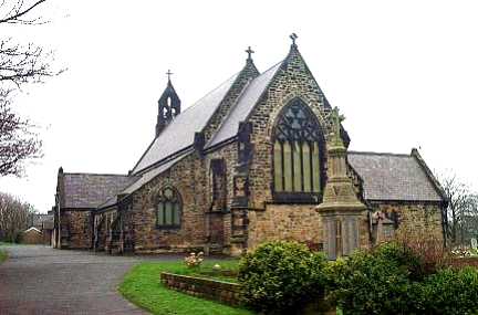