The Churches of Britain and Ireland
|
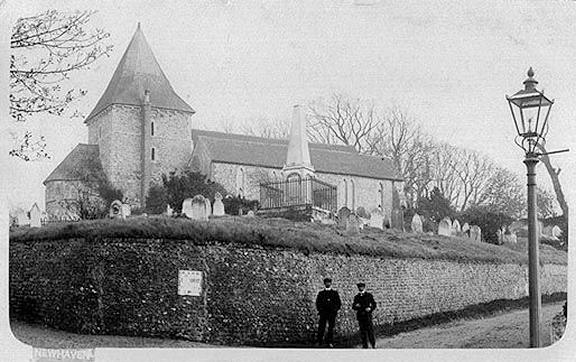
Newhaven, East Sussex The Baptist Church on Church Hill and Brighton Road, as seen by Streetview in 2024. O.S. maps show that the part of the church nearest to the camera is a later extension, the original church is that portion of the building at right angles to it. TQ 4432 0132. Link. Older O.S. maps show an otherwise unidentified Chapel on South Road at TQ 4462 0124. Its Genuki entry says it was a Baptist Chapel of 1835-1901, later demolished. Another source says it was also Primitive Methodist at some point. The building on its site was seen by Streetview in 2024. Christ Church stood on South Road, Church Road and Chapel Street. It was demolished in 1969. TQ 4461 0131. From Kevin Gordon's Collection. Link, dates it to 1881, as a Mission Church. It site was seen by Streetview in 2024. A former Congregational Chapel (2024 Streetview) stands on Meeching Road and South Way, at TQ 4450 0127. It has a date-stone for 1841, though Genuki has 1866-1938. Older O.S. maps notice a Convent on Church Hill, with a Chapel, at TQ 4432 0124. Not well seen by Streetview, Genuki has a photo of the Convent Chapel of the Sacred Heart, and supplies dates of circa 1878-1943. Elim Pentecostal Church (2024 Streetview) stands on Meeching Rise. TQ 4442 0125. Link. Sacred Heart (R.C.) is on Fort Road at TQ 4469 0094. 2024 Streetview. Genuki dates it to 1898. A map revised in 1898 shows a smaller chapel on the site, evidently replaced or extended later. This source says it has closed, but doesn't offer a date for this. St. Michael - now Anglican and Methodist. TQ 4426 0113. From an old postcard in Kevin Gordon's Collection. Link1. Link2. Grade II* listed. See here for related listed features. Chapel Street has a former Wesleyan Methodist Chapel. It survives, and was seen by Streetview in 2024. Genuki supplies dates of 1893-1940. TQ 4467 0127.
|
||
22 July 2025
© Steve Bulman
Contact Details