The Churches of Britain and Ireland
| Huntingdon, Cambridgeshire
A list of twelve vanished parish churches of Huntingdon can be found in the Victoria County History, to which reference should be made for further details. They were dedicated to Sts. Edmund, Martin, Michael, Clement, Holy Trinity, Andrew, Peter, Botolph, Nicholas, George, Lawrence and Germain.
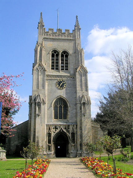
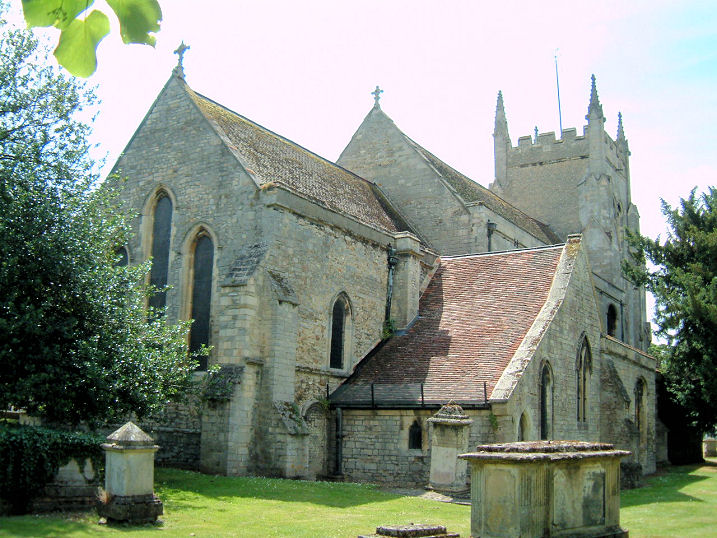
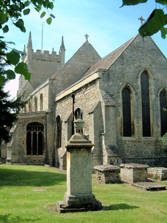
An Augustinian Priory once stood where today's cemetery is on Priory Road. Some O.S. maps mark its site with a cross a short distance east of the existing Mortuary Chapels, for which see below. A Bridge Chapel dedicated to St. Thomas the Martyr and St. Katherine once stood on the bridge over the Great Ouse, at TL 2428 7146 (grid reference is for the centre of the bridge). A Streetview of 2016 gives a general view of the bridge, and the western bank of the river. The Castle Chapel, like the castle itself, is long gone. All that remains are some mounds, now referred to as Castle Hills, or Castle Mound. It can be seen in a 2010 Streetview. TL 241 715. Link. Christian Centre on Nene Road, as seen by the Streetview van in 2009. TL 2445 7355. The demolished Huntingdon Union Workhouse had a chapel, but it's precise location within the complex of buildings isn't indicated on any available maps. The grid reference of TL 2346 7244 refers to a central point of the site. A Streetview of 2015 shows the housing built on the site of the workhouse, as seen from what was the centre of the site. Huntingdonshire Community Church on High Street was seen by Streetview in 2018. TL 2368 7200. Link. Kingdom Hall of Jehovah's Witnesses on Coneygear Road, as glimpsed by Streetview in 2015. TL 2445 7340. A relatively new building, it was preceded by another Kingdom Hall on Nene Road, which was still extant (it has since been demolished) in 2009, and recorded by the Streetview van. TL 2446 7352. A Lady Huntingdon's (Methodist) Connexion Chapel is noted as having existed in the 18th century, but nothing else seems to be known about it. The Methodist Church on High Street was most recently seen by the Streetview van in 2018. It was built as Wesleyan in 1878. There was an earlier Wesleyan Chapel (1811) in the town, but whether it was on the same site or not is so far unknown. TL 2411 7157. Link. The cemetery on Priory Road has two adjacent Mortuary Chapels, the northern one CoE, and the southerly Nonconformist, at TL 2419 7218. The CoE chapel can be seen in a 2015 Streetview. Taken from the north-west, the Nonconformist chapel is hidden from view. A Plymouth Brethren Chapel is indicated on some old O.S. maps, accessed along an alley leading north-east from High Street at TL 2416 7159. What is perhaps the entrance to the alley (if such it still is) is marked by the blue door seen in this 2016 Streetview. Also on the maps is an adjacent burial ground. This suggests that the Chapel may have previously been a Friends' Meeting House, as a directory of 1862 says "The Friends' Meeting-house is in High Street; adjoining it is a small burial-ground". The Friends' building is otherwise un-located. St. Barnabas on Medway Road, seen by the Streetview camera in 2009. TL 2450 7333. Link. The site of St. Benedict is marked on the 25" O.S. map of 1892-1914, at TL 2391 7175, on High Street. St. Benedict's Court Shopping Centre now occupies its site, and can be seen on a 2014 Streetview here. The churchyard of St. John the Baptist survives, though all above-ground traces of the church have gone. The churchyard retains some tombs, and it can be seen on a 2018 Streetview here. TL 2365 7195. A Streetview of St. John the Evangelist (1846) from 2015. It was also colloquially referred to as the New Church, or Lady Sparrow's Church. Lady Sparrow is almost certainly Lady Olivia Sparrow, a brief biography of whom is available here. TL 2365 7181. St. Mary on High Street. TL 2409 7164. © Janice Tostevin. Two additional views - 1, 2, both © Jim Rushton. Link. Grade I listed. St. Michael the Archangel (R.C.) on Hartford Road, as seen by Streetview in 2009. Various on-line sources date it to 1872 (a tin church) or 1901 for the present stone church. The church website About Us page says the parish was founded in 1872, and the church built in 1900. TL 2458 7202. Link. There is a reference in a directory of 1898 to a Salvation Army Barracks off St. Germain Street, but it has not so far proved possible to locate it exactly. The grid reference for the centre of the street, which is quite long, is TL 2398 7189. A Spiritualist Church stands on Castle Moat Road at TL 2399 7150. It can be seen here on a Streetview of 2017. Link. Trinity Free Church (Baptist and Congregational) stands on Buttsgrove Way at TL 2485 7280, and can be seen here on a Streetview of 2010. Link. Preceding it was Trinity Union Church (1868) on High Street, now demolished. The commercial premises seen on this 2014 Streetview occupy its site, though the church stood further back than the current frontage. A photo of the church, in mid-demolition in the 1960's is available here (scroll down). This in turn was preceded by the so-far-unlocated Union Chapel of 1826.
|
||
04 March 2023
© Steve Bulman