The Churches of Britain and Ireland
|
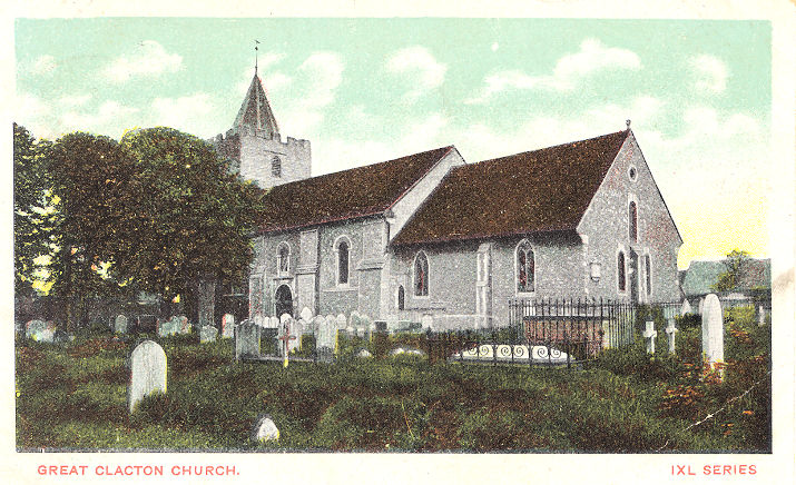
Clacton-on-Sea, Essex Bread of Life Community Church (2023 Streetview) on St. Osyth Road. TM 1706 1520. Link. Christ Church (U.R.C.) on the A133 and Holland Road - 2024 Streetview. None of the available maps label it other than as Church, or Christ Church, but it's a reasonable assumption that it was originally Congregational. The church to the right is Our Lady of Light and Saint Osyth. TM 1786 1487. Link. Clacton Christian Spiritualist Church (2023 Streetview), set back from Oxford Road. TM 1753 1552. Link. Clacton Seventh-day Adventist Church is on Rush Green Road, and was seen by Streetview in 2024. It's dated 1893. A map of 1897 labelsit as Wesleyan Mission Chapel. TM 1603 1550. Link. The Elim Pentecostal Church was seen by Streetview in 2024. It stands at the junction of Hayes Road and Alexandra Road. TM 1750 1512. Link. Holland-on-Sea Baptist Church (2024 Streetview), on Frinton Road and Norman Road. Link. The history page dates it to 1956, successor to Hainault, a wooden bungalow which they moved into in 1935, and naming it Beulah Church Mission Hall. This was on the same site as the present church, or very close to it. TM 2004 1674. Immanuel Pentecostal Church meets in Coppins Hall Community Centre on Maldon Way, seen by Streetview in 2018. TM 1576 1561. Facebook. Kingdom Hall of Jehovah's Witnesses is set back from Oxford Road, and was seen by Streetview in 2023. TM 1755 1555. The Methodist Church (2024 Streetview) is on Valley Road, and is labelled on older maps as Wesleyan - it pre-dates a map of 1880. TM 1775 1637. Link. Maps from the turn of the 19th-20th century show a Mission Hall near the N.W. corner of the junction of High Street and Carnarvon Road (the A133). Unfortunately none of the available maps show clearly which building is intended - it could either be on the north side of High Street at TM 1770 1495, or on the west side of Carnarvon Road at TM 1772 1499. In any event, it would have been visible (had it survived) in a Streetview from 2024. Old maps also show another Mission Hall, on St. Andrew's Road, at TM 1725 1538. It survives as St. Andrew's Hall, seen by Streetview in 2014. Our Lady of Light and Saint Osyth (R.C.) as seen by Streetview in 2024 - 1, 2. TM 1790 1489. Link. Grade II listed - dates it to 1902-3. The lych-gate (2024 Streetview) is also listed, at grade II. Pier Avenue Baptist Church on Pier Avenue was seen by Streetview in 2024. TM 1728 1500. Link. The history page dates it to 1928-9, successor to two earlier churches, a small brick building, and a tin tabernacle. Although their exact locations aren't specified, the first one stood on Pier Avenue, so in all likelihood the 2 earlier churches were on the same site as the present one. It also says that at one time services were held at the Winter Gardens Hall in Wash Lane - I haven't been able to locate this. The Primitive Methodists had a chapel on Old Road at TM 1728 1568. Pre-dating a map of 1880, it had gone out of use no later than 1954. Demolished, its site was seen by Streetview in 2024. The Quaker Meeting House is set back from Granville Road, and seen by Streetview in 2024. TM 1787 1525. Link. St. Bartholomew on Colchester Road, Holland-on-Sea, as seen by Streetview in 2023. TM 1948 1643. Link. St. James on Beatrice Road and Tower Road - 2009 Streetview. TM 1721 1453. Link. Grade II* listed wherein it's dated to 1912-13. St. John the Baptist at Great Clacton. From an old postcard in Steve Bulman's Collection (franked, 1905). Its appearance has changed since then with the addition of wooden boarding to the top portion of the tower - see the photo on the church website. TM 1770 1654. Link. Grade I listed. St. Mark on Lymington Avenue, as seen by Streetview in 2024. TM 1819 1766. Link. St. Paul was seen by Streetview in 2024. It stands at on Church Roadand St. Alban's Road at TM 1824 1512. Older maps show that this is the second church on the site, the earlier one (of 1875) stood a little further to the west where the church hall (?) now stands - 2024 Streetview. A photo of it can be seen here. TM 1821 1510. Link. The Salvation Army Church (2018 Streetview) is on Old Road and St. Osyth Road. It was originally a Primitive Methodist Chapel (Zion), dated here to between 1904 and 1921. There's an old photo which shows a chunky steeple, now removed. TM 1718 1519. Link. Trinity Methodist Church stands on Pier Avenue at TM 1734 1490. Older maps label it as Wesleyan. 2024 Streetview. Link.
|
||
10 August 2025
© Steve Bulman