The Churches of Britain and Ireland
| Brechin,
Angus
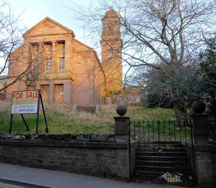
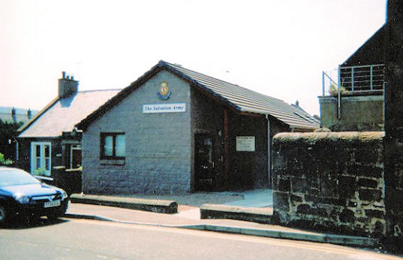
Cathedral Church of the Holy Trinity. The Round Tower. NO 5962 6009. Both © Derek Robertson. Link. Category A listed. The tower is separately listed, also as Category A. A former Congregational tin tabernacle stands on Southesk Street at NO 6008 6006. Seen by Streetview in 2008, it was also known as Ebenezer Hall, as mentioned here, although whether this was when it was Congregational, or under a different ownership, is unclear. It survived until 2016 at least, when it was photographed again, seen here, further hidden by greenery. East Church, now demolished, stood on City Road at SO 5984 6021. It was built before 1838, as this source mentions damage to the steeple from high winds in that year. Its site was seen by Streetview in 2008 - the church occupied the further half of the white painted terrace, and ground to either side. The former East Free Church on Panmure Street and Southesk Street. Its category A listing dates it to 1856. A Streetview of 2015 provides another view. NO 5987 6042. © Derek Robertson. Gardner Memorial Church stands at the corner of Damacre Street and Southesk Street. It was re-named from Southesk Church in 1997. It was seen by Streetview in 2008. NO 6003 6016. Category A listed, wherein it's dated to 1896-1900. The Jehovah's Witnesses had at least two Kingdom Halls in the town. Which preceded the other is so far unclear. One stands at 59 Southesk Street - NO 6004 6027 - and was a Kingdom Hall at the time of its Category C listing in 1979. The building itself is of 1858, and was seen by Streetview in 2008. Link. The other Kingdom Hall, at 15 Bank Street was seen in 2009, and is also Category C listed. NO 5992 6030. The remains of the medieval Maisondieu Chapel on Maisondieu Lane, as seen by Streetview in 2020. NO 5967 6034. Category A listed, which dates it to 1256. The former Maison Dieu (CoS, originally United Free) on Witchden Road. A 2021 Streetview provides another view. NO 6016 5975. © Derek Robertson. Canmore entry. Category B listed, wherein it's dated to 1891. A map of 1822 shows a Methodist Chapel (of undetermined flavour) off Dodds Wynd (now City Road). It may be the chapel mentioned here as having been built in 1798. By 1862 it was a Music Hall. Its site is now surrounded by housing - it stood roughly where the tall bush is in the background of a Streetview from 2008. NO 5993 6004. The site (the nearest part of the car park) of St. Andrew (Episcopal), which stood on Maisondieu Lane and St. Andrew's Street, as seen by Streetview in 2020. Are the gateposts a survival? The Wikipedia entry at the head of this page dates it to 1809. It was later Holy Trinity (R.C.), perhaps following the move of the congregation of St. Andrew to a new church on Argyll Street in 1888 (for which, see the next entry). NO 5959 6029. Canmore entry. St. Andrew (Episcopal) on Argyll Street was seen by Streetview in 2008. NO 5953 6038. Category B listed, wherein it's dated to 1888. Link. St. Ninian (R.C., previously United Free) on Bank Street. Streetview saw it in 2008. Its category B listing dates it to 1875-6. NO 5998 6028. Salvation Army Hall on Southesk Street. A 2008 Streetview provides another view. NO 6040 5973. © Rob Brettle. Link. A United Free Church once stood on City Road, close to East Church, at NO 5985 6018. Its site was seen by Streetview in 2008. A building of 1881 marks the site of a United Presbyterian Church on High Street, at NO 5975 6015. The church was present on a map of 1862, and on another of 1822 it's labelled as English Episcopal. It was seen by Streetview in 2020. Another United Presbyterian Church stood on Maisondieu Lane, at NO 5963 6030. It shows on a map of 1822. Now a car park, its site was seen by Streetview in 2020. West United Free Church stood on Church Street at NO 5964 6019. Pre-dating a map of 1903, it seems to have still been active when the 1" map of 1957 was published. The site, now a car park, was seen by Streetview in 2016.
|
||
04 March 2023
© Steve Bulman