The Churches of Britain and Ireland
| Bognor Regis, West Sussex
Bognor Regis
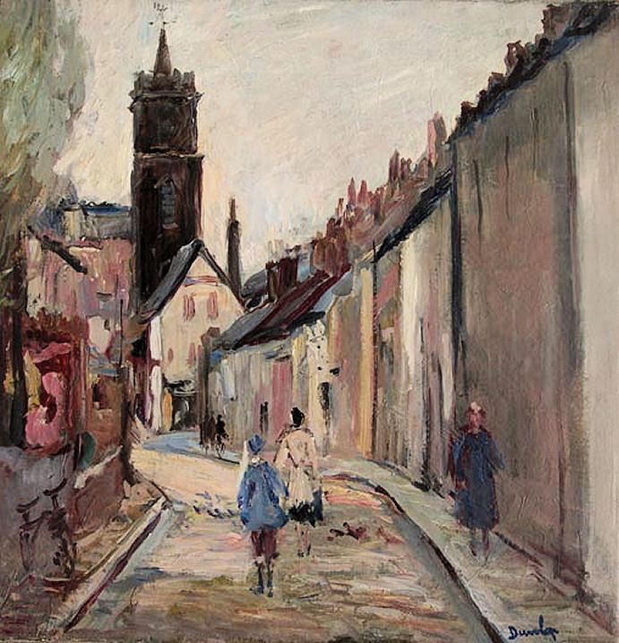
on Wikipedia. Aldwick Baptist Church stands on Gossamer Road - 2022 Streetview. Z 9073 9908. Link. The about us page dates it to 1938, with later extensive enlargement. Bognor Regis Spiritualist Centre on Sudlkey Road, as seen by Streetview in 2022. SZ 9369 9916. Link. A map of 1879 shows a Chapel on High Street and London Road at SZ 9363 9908. It had gone out of use no later than 1934. None of the available maps identify it more closely. It's most probably the High Street Congregational Church listed here, dating from 1866-1929. The latest Streetview (2015) shows a bank on its site. A photo of the Congregational Church can be seen here. Another Chapel on High Street post-dates the 1879 map, appearing by 1912 and no longer labelled as a place of worship by 1934. SZ 9359 9905. Shops now stand on its site (2015 Streetview). Genuki identifies it as a Wesleyan Methodist Chapel, dated 1840-1925, demolished 1980. Yet another unlabelled Chapel shows on old maps on the west side of The Steyne at SZ 9327 9891. Built by 1896, it's no longer labelled as Chapel in 1934. Genuki has it as Primitive Methodist (1876-1932), Plymouth Brethren from 1932, demolished in 1975. I think the building on its site is shown between the trees in a Streetview from 2022. A 6" map of 1899 shows an otherwise unidentified Church (site of, 2022 Streetview) on the north side of Aldwick Street, at SZ 9136 9879, while on the 25" map of 1912, it has vanished, and another Church (site of, left of the driveway, 2022 Streetview) appears nearby on the south side of the road at SZ 9142 9871. By 1932 this too had vanished. Could these both have been predecessors of St. Richard (2022 Streetview) on Gossamer Lane and St. Richard's Way, which dates from 1933? Please get in touch if you can throw any light on either of the two demolished churches. SZ 9096 9904. Link. Aerial views suggest that the cemetery on Town Cross Avenue has retained a Mortuary Chapel, shown on maps from 1899. It can't find a Streetview which shows it, and haven't found a photo. Also pre-dating the 1899 map is R.C. Chapel, on Clarence Road, at SZ 9383 9913. It's still active as Our Lady of Sorrows (2022 Streetview). Its grade II listing dates it to 1881. Another 2022 Streetview gives a view from the rear. Link. St. John the Baptist or Evangelist (depends on source consulted; none of the available maps show it except as St. John, at best. Because St. John which replaced it (see next entry) was St. John the Baptist, I suspect that this church was Baptist too). A Bognor mystery was sent in by Peter Boyce who wanted to learn where this painting was produced. It's by R. O. Dunlop R.A. whose floruit was in the 1950's and 1960's. He lived near Chichester, and painted widely in Sussex and further afield in southern England. Colin Waters identified the painting on this website (not working when re-tested in 2026), and it is called "Old Street, Bognor". Unfortunately, there isn't a thoroughfare called Old Street in Bognor, so this is just a generic old street. In a fine piece of detective work, Tony Preston has also been looking into this church. He points out that the website included earlier in this entry also has an image of a page from a magazine, wherein the painting is shown, with the title Old Bognor Street, rather than Old Street, Bognor, supporting my assumption that Old Street as such doesn't exist. It also includes a hand-written date of 1956 for the painting. He has sent a link (here) to a website describing the church of St. John , built in 1821, with a tower added circa 1834. The church itself was demolished 1891, but the tower was left standing until 1961 (i.e. after the painting was made). This link (again, not working in 2026) shows two postcards (scroll down) of Waterloo Gardens, both showing the church in the background, a good match for the painting. An old map shows St. John's tower standing on Market Street, and comparing the painting with the map, I suspect that the view is from what was then Chapel Street, to the north of Market Street. Note that Chapel Street has since been re-routed from its original course. Circa SZ 9332 9892. [Peter - the email address I have for you is invalid, so I hope you see this]. St. John the Baptist stood on a site between London Road and Sudley Road, at SZ 9357 9924. Dated here to 1880-6 by Blomfield, closed 1971, demolished 1972. Exterior and interior photos here. St. Mary Magdalene at South Bersted. Previously in the "Unknown" section, my thanks to Phil Draper for the identification. SZ 9347 0022. From Steve Bulman's Collection. Link1. Link2. Grade II* listed. Some of the churchyard wall is also listed, as grade II. St. Wilfrid (2019 Streetview) stands on Victoria Drive and Ellasdale Road, at SZ 9284 9894. Link. Old maps show that it had a predecessor of the same dedication nearby, a little further south - about where the tree stands - seen in a Streetview from 2022. It was built no later than 1896, and had vanished by 1910. Perhaps a tin tabernacle?
|
||
22 April 2026
© Steve Bulman