The Churches of Britain and Ireland
| Ardwick, Manchester, Greater Manchester
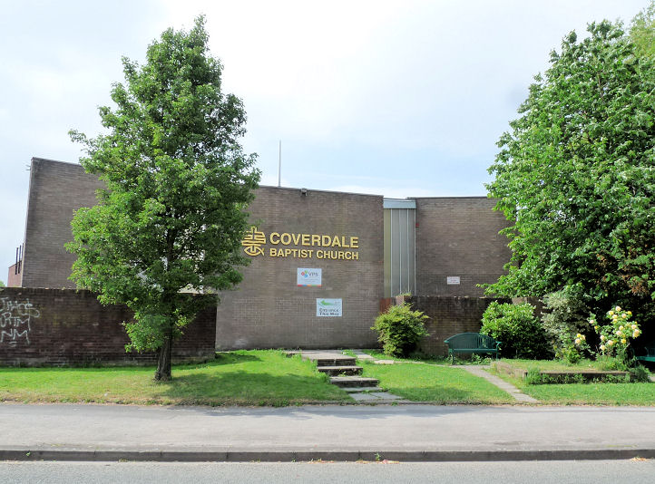
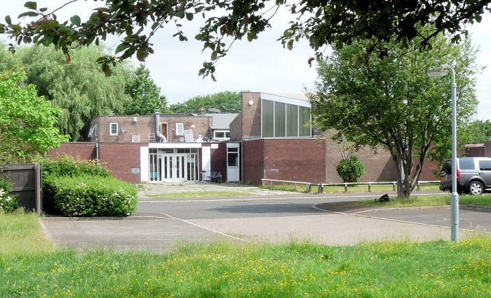
The football field on Dalberg Street used to be Ardwick Cemetery, and it had a Mortuary Chapel at SJ 8568 9706. Nicholls Community Football Centre now stands on the site (2020 Streetview). There used to be a Baptist Chapel at the corner of Clowes Street (now Beastow Road) and Kelsall Street, at SJ 8682 9682. It's labelled on a map of 1889 as Union Chapel (General Baptist). The site is now given over to housing, seen by Streetview in 2023. Genuki mentions an Independent Chapel on Indigo Street, founded before 1851, closed before 1891. It must be what is shown on a map of 1849 as Bridge Street Chapel (Independent) on the corner of Indigo Street and Bridge Street. Its site is now at the further edge of the road on the pavement and grass, as seen in a Streetview from 2023. SJ 8559 9773. Google maps shows Christ The Solid Rock Chapel International at 22 Dolphin Street. The building displays no signs in 2023, though from 2012 to 2019 there was a sign for Spirit and Life Bible Church International. SJ 8551 9708. Link. Coverdale Baptist Church on The Well, Coverdale Crescent. Another view. SJ 8625 9669. Both © Mike Berrell (2018). Link. It may have been successor to Emmanuel Baptist Chapel on the nearby Garibaldi Street, which Genuki mentions. However, no available maps show it. The chapel and road have both gone. Evangelical Church of the Lamb Ministries on Dolphin Street. SJ 8553 9707. © Mike Berrell (2010). Link. Fabric Church meets in a building called FAC251 (2023 Streetview) on Princess Street. SJ 8435 9750. Link. Jubilee Church (Redeemed Christian Church of God) on Redgate Lane, as seen by Streetview in 2023. SJ 8679 9658. Link. Manchester Vineyard meets in Dean Trust Ardwick (2021 Streetview), which stands on the A6 and Daisy Mill Road. SJ 8616 9632. Link. A Presbyterian Church used to stand on Union Street, dated by Genuki to 1877 to 1946 (closed). Demolished, its site (2021 Streetview) remains undeveloped beside the Ring Road. SJ 8553 9761. Both Genuki and My Primitive Methodists mention a Primitive Methodist Mission on or near Grey Street, the latter source dating it to 1898. No available maps show it. There was a short-lived Primitive Methodist Chapel on Hyde Road, dated by Genuki to 1863-1878, however this source says that baptism records exist for the chapel to 1904. According to the latter source, it was a large and handsome building. No available maps show it. A Primitive Methodist Chapel stood at the junction of Park (now Harkness) Street and Higher Ardwick. A photo is available here, where its opening date is given as 1878. Its site is now a car park (2023 Streetview). The building to the left is the surviving former Sunday School. SJ 8544 9720. Link, wherein its closure date is given as 1964. Its predecessor was on Ogden Street, and dated here to 1850-1878. No available maps show it, but one may speculate that it might have been converted into the cinema shown on a map of 1922. If this is the case, then it stood at SJ 8557 9763. Link. A map of 1891 shows St. Aloysius (R.C.) on Park Street (now Harkness Street) and Park Place (now Palfrey Place). Genuki dates it to 1854-1988. An interior photo can be seen here. Its site remains undeveloped as of 2023 (Streetview). SJ 8547 9719. The former St. Benedict on Bennett Street, now Manchester Climbing Centre. SJ 8655 9698. © June Fitzgerald. Another view, © Mike Berrell (2011). Link (to the Climbing School). St. Jerome on Baden Street and Ferry Street. Previously incorrectly listed as St. Silas. Thanks to Mike Berrell for the correction. The 25" map of 1922 labels it as Memorial Church. SJ 8639 9779. © June Fitzgerald. Its Genuki entry dates its foundation to 1913, with closure "by 2007". The area has been completely redeveloped, and the church, and even the streets, have gone. It was still standing in 2015 (Streetview), gone by 2018 (Streetview), and as the site appears on the latest Streetview of 2023. St. Matthew used to stand on Hyde Road, between Tiverton Road and Devonshire Street, at SJ 8575 9691. This source has an interior photo, and dates it to 1866-8. Genuki says it was closed in 1975. It was demolished at some point before 2008, when the earliest Streetview was taken. Its site remains under grass (2023 Streetview). St. Silas used to stand on Ashton Old Road at SJ 8601 9759. Its Genuki entry dates it to 1842-1954. An old illustration can be seen here. A commercial building now stands on the site (2023 Streetview). Older Streetviews show that it had gone before 2008. The former St. Thomas on Niven Street. SJ 8518 9732. © June Fitzgerald. Link. Grade II listed, wherein it's dated to 1741, with later additions and enlargements. A Salvation Army Hall is shown on a map of at the corner of Grey Street and Earl Street. SJ 8621 9661. It stood behind what is now housing on Halsbury Close, seen here in a Streetview from 2023. Genuki lists a School Mission (Wesleyan Methodist) on Chancery Lane (now Chancellor Lane), dating it to 1817-1967. This will be what is labelled on a map of 1851 as Chancery Lane School (Sunday) which stood at the corner of York Street and Chancery Lane at SJ 8575 9747. Its site (2023 Streetview) is now a parking area adjacent to a petrol station. Genuki also lists another Wesleyan School Mission, on Rylance Street, founded before 1892. This is probably the Mission Hall shown on a map of 1892-1914 at SJ 8641 9770. In this 2023 Streetview it would have stood behind the tree. The only other candidate is a church hall a little way north, but it seems not to have been built until after 1905. Spirit and Life Bible Church International on Dolphin Street - see the entry for Christ The Solid Rock Chapel International above. Genuki lists a Spiritualist Hall on Grey Street, dating it to "before 1901". The grid reference is very close to what I have listed as the Salvation Army Hall, so may have been the same building. Tipping Street Independent Chapel stood on Tipping Street, at SJ 8532 9745. Genuki gives its date of foundation as 1835. It seems to have closed before 1905. Its site (2023 Streetview) is by the side of the Ring Road. A map of 1891 shows a Methodist Chapel (United) on Hyde Road at SJ 8584 9688. Genuki calls it a United Methodist Free Church, and dates its founding to before 1865. It doesn't show on a map of 1851. A nursery school (formerly the Star Inn) stands on the site (2023 Streetview). It may be the church visible in this illustration of "Ardwick Green and Methodist Free Church". A Welsh Calvinistic Methodist Chapel shows on a map of 1891 on Higher Ardwick, at SJ 8551 9724. Genuki says it was founded by 1888, and it seems to have closed before the mid-20th century. A commercial building now stands on the site (2023 Streetview). Hyde Road had, as well as Primitive and United Methodist chapels, a Wesleyan one, on the corner of Chapel Street at SJ 8661 9665. Chapel Street no longer exists. A commercial building stands on the site today (2023 Streetview).
|
||
08 January 2024
© Steve Bulman