The Churches of Britain and Ireland
|
Annfield Plain, County Durham
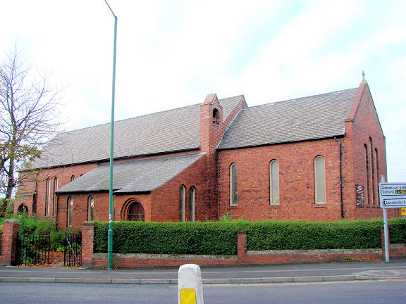
Catchgate Methodist Church on Library Terrace, Catchgate, as seen by Streetview in 2023. A 1920 map shows it as United Methodist. NZ 1668 5192. The Central Methodist Church (2023 Streetview) is on Welsh Terrace and Railway Street. None of the available maps indicate what flavour of Methodism it may originally have been. NZ 1714 5147. Link. An otherwise unidentified Chap. shows on a map of 1896 on New Front Street, at NZ 1690 5155. Whether the shop on the site today (the taller one, gable end to the street) seen by Streetview in 2023 is the former chapel, or a later building, is unclear. A small side road (2018 Streetview) off Blackett Street, Catchgate, marks the site of a Free United Methodist Chapel, shown on an O.S. map from 1896. It was no longer labelled by maps of the mid 20th century, and demolished at some point. Early O.S. maps show a Mission Room on Harperley Road, West Kyo, at NZ 1699 5244. No longer labelled by the time of mid-20th century maps, its site was seen by Streetview in 2023. A Primitive Methodist Chapel shows on the 25" map of 1920 off Shieldrow Lane at NZ 1778 5161. At some point Kyo Laws Methodist Church (2009 Streetview) was built in front of it. The brick building to its rear wasn't the P.M. Chapel, as it was on a different alignment. Kyo Laws Methodist has since closed. St. Aidan on Shield Row Lane. It dates from 1925, 1928, or 1929-30, according to the source consulted. It was closed in 2016 according to this source, which is the one which dates it to 1925, and it says it replaced a temporary Mission Hall. Map evidence shows that this was on the same site, dating back to the early 1920's. NZ 1726 5125. © Bill Henderson. St. Teresa (R.C) on James Street, as seen by Streetview in 2023. NZ 1723 5159. Link. St. Thomas on North Road, Catchgate. NZ 1618 5260. Trees prevent good views on Streetviews, as seen here in 2009. Link. Grade II listed (better photos here) - dates it to 1840. O.S. maps from the early 20th century show an otherwise unidentified Ch. on South View, at NZ 1750 5145. Only a 25" map from 1920 labels it as U.M. Church. It survives, though evidently closed, and was seen by Streetview in 2023. There used to be a Wesleyan Methodist Chapel on New Front Street at NZ 1685 5177. Showing on a map of 1895, one of 1861 shows an earlier, smaller, predecessor on the same site. The church shows as still active on a map of 1961, but has since been closed and demolished. An old postcard view of the church can be seen here. Housing has been built on its site, seen by Streetview in 2023.
|
||
13 February 2025
© Steve Bulman