The Churches of Britain and Ireland
| Annan, Dumfries & Galloway
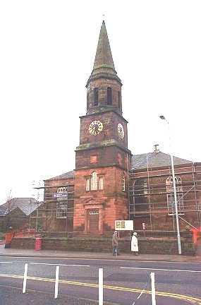
O.S. maps show a Church near to the railway station on maps from 1861 to 1956. The only one of these to say anything more is the one from 1861, where it's labelled as Church Quoad Sacra. It stood on a triangle of land between Station Road and St. John's Road at NY 1935 6623, and the present building there was seen by Streetview in 2021. Can you name it? Hope Church (Pentecostal) meets at Kate’s Kitchen, The Old Bank (2016 Streetview), on High Street. NY 1927 6661. Facebook. The Old Parish Church of Scotland, on Church Street. NY 1959 6661. © Bill Henderson. Link. Category A listed - dates it to 1789. St. Andrew (CoS) on Bank Street, as seen by Streetview in 2009. It shows as Free Church on older maps. NY 1937 6649. Link. Category B listed dates it to the early 19th century. St. Columba (R.C.) on Scott's Street (2021 Streetview). It pre-dates a map of 1861. NY 1994 6646. Link. St. John the Evangelist (Episcopal) on St. John's Road, as seen by Streetview in 2021. NY 1937 6639. Link - advises of closure. Category B listed, wherein it's dated to 1842-3. Older O.S. maps show a United Presbyterian Church on Bank Street. Its category B listing calls it Erskine Parish Church, and dates it to the early 19th century. It seems to have gone out of active use in the middle of the last century. There are only two Streetviews. The earliest, of 2009, shows it as derelict and boarded up, the second, from 2021 as just a shell. U.R.C. (2021 Streetview) on Station Road and Fruids Park Avenue. NY 1926 6634. Link.
|
||
31 January 2025
© Steve Bulman