The Churches of Britain and Ireland
| Acock's Green,
Birmingham
The
Acock's Green History Society
website has much useful information, and it will be referred to
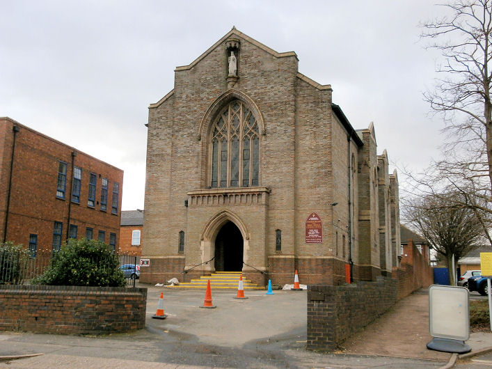
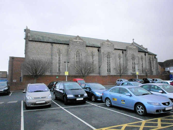
below as AGHS. Acocks Green Christian Centre (Elim Pentecostal), off Westley Road at SP 1179 8302. The church can be seen in the distance, approached by the alleyway between two houses in a 2022 Streetview. Link. Acocks Green Masjid is on Alexander Road, and was seen by Streetview in 2022. SP 1180 8386. The Baptist Church (2020 Streetview) is on Yardley Road at SP 1241 8371. Its grade II listing dates it to 1913. It was preceded by what is now the church hall cum Sunday School around the corner on Alexander Road (2019 Streetview), dated in its grade II listing to 1903. A 2020 Streetview shows both buildings. Link. AGHS entry. Christadelphian Hall (2021 Streetview) stands on the west side of Station Road at SP 1219 8331. Link. The Our History page dates the congregation to 1890, and the present building to 1906. Church of God of Prophecy off Broad Road at SP 1178 8322. Streetviews in 2008 and 2020. Facebook. It was the venue for an edition of BBC Radio 4's Sunday Worship in 2023 - link. There have been two Independent/Congregational Chapels on Stockfield Road, both demolished, one quite recently. The earlier chapel, of 1827, demolished in 2012, was at SP 1161 8394. The only Streetview to capture it was the first, in 2008. The adjacent garage was then extended to include the chapel's site (2022 Streetview). The second (its successor) was of 1860, closed circa 1956, and demolished circa 1973. It was at SP 1151 8379. As of 2022 its site (Streetview) remains un-developed. Photos of both buildings (and one of the interior of the second church) can be seen on their AGHS entry. A Methodist Chapel of 1882 (originally Wesleyan) stands on the east side of Shirley Road. Immediately adjacent to it is an extension of 1927, which stands on the site of the original Wesleyan Chapel of 1863. In this 2008 Streetview, the later chapel is to the left, extension to its right. Another Streetview, from 2016. SP 1205 8293. Link. AGHS entry. 1" maps of 1951 and 1959 show a place of worship at the corner of Rookwood Road and Arden Road, at SP 1198 8362. Although the small scale maps which show it put it further south that the building line existing today (implying the place of worship stood in the loop of garden in this 2022 Streetview), the building a little further back looks church-like, and bears a sign for Birmingham City Mission. Their about us page date their time here to no earlier than the 1980's. The AGHS entry for St. Mary's Church says that "St. Mary's used to have several outlying buildings", included amongst which was Church House, the existing building under discussion, but it doesn't say what it was used for. According to this AGHS entry, there used to be a Primitive Methodist Chapel of 1892 on Station Road. It isn't indicated on any available on-line maps, so must have been fairly short lived. Howard Richter has suggested that it may have been what is labelled as a Club on the 25" map of 1913, standing immediately south of the Christadelphian Hall, and the site of which now serves as the Christadelphian Hall car park (2021 Streetview). Confirmation (or correction) of this theory would be welcome! Sacred Heart and Holy Souls (R.C) on Warwick Road. The foundation stone was laid in 1923, opened in 1925, with final completion in 1940. Another view. SP 1239 8312. Both © Howard Richter (2013). Link1. Link2 - a comprehensive history, with photos of the predecessor churches - a greenhouse from 1905, and a school from 1907. St. Mary the Virgin on Warwick Road. Its grade II listing dates it to 1864-82, with later additions, and was initially a chapel of ease to St. Eadburgha's in Yardley. Two Streetviews from 2022 - 1, 2. SP 1199 8331. Link1. Link2. Numerous photos here, including interiors.
|
||
18 January 2024
© Steve Bulman